- Home
- Apps
- Maps & Navigation
- ALTLAS: Trails, Maps & Hike
ALTLAS: Trails, Maps & Hike
234 TRUSTED APP
v5.1.4 by Erol1Apps


About ALTLAS
ALTLAS (Package Name: altitude.alarm.erol.apps) is developed by Erol1Apps and the latest version of ALTLAS: Trails, Maps & Hike 5.1.4 was updated on July 25, 2024. ALTLAS: Trails, Maps & Hike is in the category of Maps & Navigation with the feature Tools. You can check all apps from the developer of ALTLAS: Trails, Maps & Hike and find 200 alternative apps to ALTLAS: Trails, Maps & Hike on Android. Currently this app is for free. This app can be downloaded on Android 7.1+ on APKPure.fo or Google Play. All APK/XAPK files on APKPure.fo are original and 100% safe with fast download.
Explore, record, and share your activities, Navigate any trails and GPX files using the most accurate altimeter and tracking information with the Altimeter - Activity tracker. Find hiking trails, record your activities with the GPS, and Import/export GPX trails.
Download the ultimate activity tool today!
ALT-LAS Can be used as a Bike computer use it on your bike, bicycle, scooter, and more!
By using the app you can get:
1. Elevation finder and activity tracker.
2. The app has a unique database of many trails around the world that was recorded by the users so you get the best hiking trails.
3. The app finds your altitude, peak points, barometric pressure, speed, and more!
4. The app alerts you against altitude limitations and is suitable for a variety of activities such as Walking, Trekking, Flights, Cycling, Skiing, biking, and more.
Have you ever searched for "walks near me?" or find elevation? now you can get it immediately with ALT-LAS.
Help build a community that shares routes and places around the world.
Measuring altitude modes:
1. GPS mode: the application measures the altitude using the GPS and performs a unique correction to provide an accurate altitude.
Note, that the altitude readings may be inaccurate when the GPS signal is weak.
2. Barometer sensor (a device with a barometer sensor): the application can work with the device’s barometer sensor that is auto-calibrated with the environment.
In this mode, the application can work inside buildings without GPS.
Features:
- Track activities
- Trail navigation
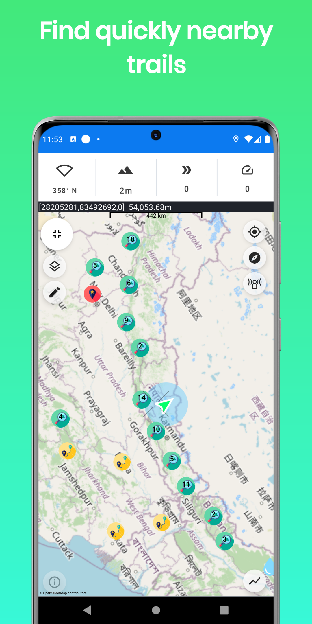
- Explore new trails
- Offline maps (Pro version)
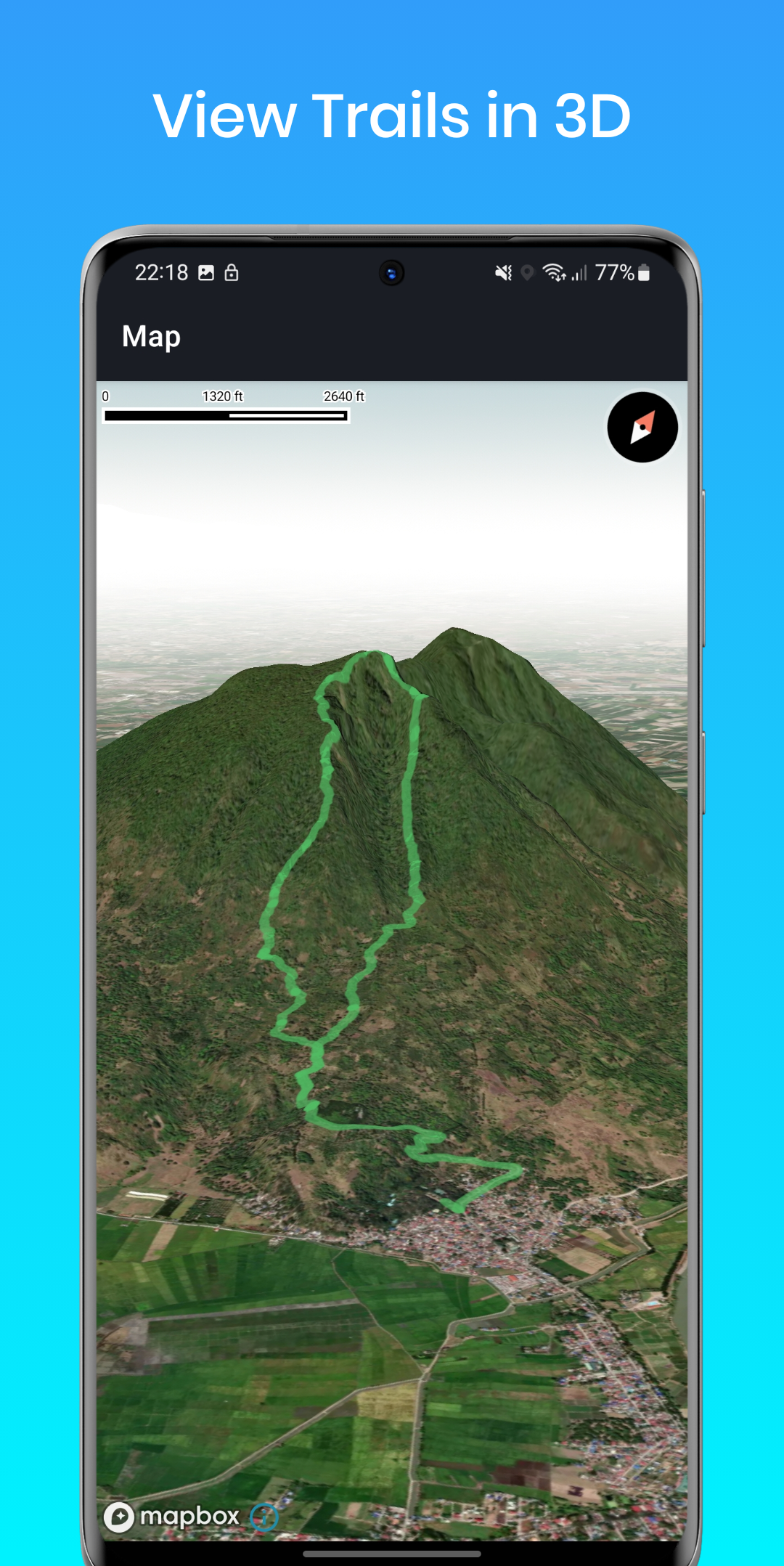
- View Trails in 3D (Pro version)
- Track your elevation
- Altimeter to get your current altitude.
- Discover and share tracks
- Weather forecast
- Elevation map
- Compass with lock bearing
- Steps & Calories calculator
- Share live location (Subscription only)
- Real-time altitude graph
- Altitude limit alerts
- Save landmarks
- Barometric pressure
- Import/export GPX files
- Climbing information
- The Altimeter can work offline (flight mode)
- Get indoor/outdoors altitude
- Periodic altitude voice notification
- Different map types: Topographic, Open Street Map, hike & bike, and Satellite (Premium only).
- Sensor info (Supported devices only) such as Barometer, Temperature, Light, and Humidity.
- Dark mode
Planning and Navigation tools:
- Measure route and vertical distance
- Routing: get the fastest route between any location to another.
- Get coordinates on the map
- Estimate time of arrival
- Circular boundary
SUPPORT:
For any questions or suggestions, feel free to contact us:
Check the Telegram channel where you can ask questions, and ideas, request features, share your activities, and more: https://t.me/ALTLASAPP
User Manual & FAQ
https://altlas-app.com/support.html
Customer support:
[email protected]
Website:
www.altlas-app.com
Download the app now and get started!
The use of this app or any of its content is at your own risk.
If you liked the app, please rate it!
Download the ultimate activity tool today!
ALT-LAS Can be used as a Bike computer use it on your bike, bicycle, scooter, and more!
By using the app you can get:
1. Elevation finder and activity tracker.
2. The app has a unique database of many trails around the world that was recorded by the users so you get the best hiking trails.
3. The app finds your altitude, peak points, barometric pressure, speed, and more!
4. The app alerts you against altitude limitations and is suitable for a variety of activities such as Walking, Trekking, Flights, Cycling, Skiing, biking, and more.
Have you ever searched for "walks near me?" or find elevation? now you can get it immediately with ALT-LAS.
Help build a community that shares routes and places around the world.
Measuring altitude modes:
1. GPS mode: the application measures the altitude using the GPS and performs a unique correction to provide an accurate altitude.
Note, that the altitude readings may be inaccurate when the GPS signal is weak.
2. Barometer sensor (a device with a barometer sensor): the application can work with the device’s barometer sensor that is auto-calibrated with the environment.
In this mode, the application can work inside buildings without GPS.
Features:
- Track activities
- Trail navigation
- Explore new trails
- Offline maps (Pro version)
- View Trails in 3D (Pro version)
- Track your elevation
- Altimeter to get your current altitude.
- Discover and share tracks
- Weather forecast
- Elevation map
- Compass with lock bearing
- Steps & Calories calculator
- Share live location (Subscription only)
- Real-time altitude graph
- Altitude limit alerts
- Save landmarks
- Barometric pressure
- Import/export GPX files
- Climbing information
- The Altimeter can work offline (flight mode)
- Get indoor/outdoors altitude
- Periodic altitude voice notification
- Different map types: Topographic, Open Street Map, hike & bike, and Satellite (Premium only).
- Sensor info (Supported devices only) such as Barometer, Temperature, Light, and Humidity.
- Dark mode
Planning and Navigation tools:
- Measure route and vertical distance
- Routing: get the fastest route between any location to another.
- Get coordinates on the map
- Estimate time of arrival
- Circular boundary
SUPPORT:
For any questions or suggestions, feel free to contact us:
Check the Telegram channel where you can ask questions, and ideas, request features, share your activities, and more: https://t.me/ALTLASAPP
User Manual & FAQ
https://altlas-app.com/support.html
Customer support:
[email protected]
Website:
www.altlas-app.com
Download the app now and get started!
The use of this app or any of its content is at your own risk.
If you liked the app, please rate it!
ALTLAS 5.1.4 Update
5.1.4
1. General Improvements.
2. Fix a bug now showing points of interest.
3. The nearby points now include Wikipedia points.
5.1.3
1. New map Types: Raster Topographic, OSM, and Rails maps!
2. Now you can sync and edit your trails with our new Connect web.
3. Enable private upload. now all your trails will be saved and synced automatically in our cloud.
4. Minor bug fixes.
Do you have any issues or suggestions? Please write to us at [email protected]. We appreciate your feedback!
Read More
Related Videos


Previous Versions More
ALTLAS: Trails, Maps & Hike
5.1.4
XAPK
APKs
July 23, 2024
37.95 MB
Variant
Arch
Version
DPI
ALTLAS: Trails, Maps & Hike
5.1.3
XAPK
APKs
July 18, 2024
46.3 MB
Variant
Arch
Version
DPI
ALTLAS: Trails, Maps & Hike
5.1.2
XAPK
APKs
July 15, 2024
46.14 MB
Variant
Arch
Version
DPI
ALTLAS: Trails, Maps & Hike
5.1.1
XAPK
APKs
June 13, 2024
37.71 MB
Variant
Arch
Version
DPI
More Information
Package Name:
Category:
Update Date:
2024-07-25
Latest Version:
5.1.4
Need Update:
Available on:
Requirements:
Android 7.1+
Report:
Alternatives to ALTLAS
Organic Maps: Hike Bike Drive
Navigate with Privacy - Community-Driven & Open-Source
9.3 694
Zeo Fast Multi Stop Route Plan
Get home faster. Shortest & fastest routes for multi stop deliveries
9.0 1K+
Compass Maps
Digital Compass maps and land area measurement on maps
9.9 5K+
komoot - hike, bike & run
Discover new routes, plan hikes, rides & runs, and navigate your adventures.
8.6 34K+
Just Draw It! - Route planner
Route planner and distance finder at the tip of your fingers. Literally.
8.6 452