- Home
- Apps
- Maps & Navigation
- FLY is FUN Aviation Navigation
FLY is FUN Aviation Navigation
200 TRUSTED APP
v33.80 by Petr Kouřil


About FLY is FUN
FLY is FUN (Package Name: gps.ils.vor.glasscockpit) is developed by Petr Kouřil and the latest version of FLY is FUN Aviation Navigation 33.80 was updated on November 8, 2024. FLY is FUN Aviation Navigation is in the category of Maps & Navigation. You can check all apps from the developer of FLY is FUN Aviation Navigation and find 161 alternative apps to FLY is FUN Aviation Navigation on Android. Currently this app is for free. This app can be downloaded on Android 5.0+ on APKPure.fo or Google Play. All APK/XAPK files on APKPure.fo are original and 100% safe with fast download.
FLY is FUN is designed by pilots for pilots. FLY is FUN simplify flight preparation and improve situation awareness during flight, providing information on airspaces, reporting points, position on moving map, elevation, frequencies, railway, weather info … facilitate access to airfields related PDF document. Application also displays NOTAMs and data from rainfall radars.
FLY is FUN simulates ILS approach, VOR, NDB, DME, Marker beacons, RNAV navigation and Marker beacons warnings, without ILS/VOR/NDB/RNAV equipment on board.
You can test FLY is FUN for free during few days. At the end of the trial period, pilot is invited to subscribe and pay an annual fees. Doing it, he get the right of using the application "as it is" and contribute to development effort.
FLY is FUN allows:
- Creating and modifying routes using "drag and drop", "rubber band"
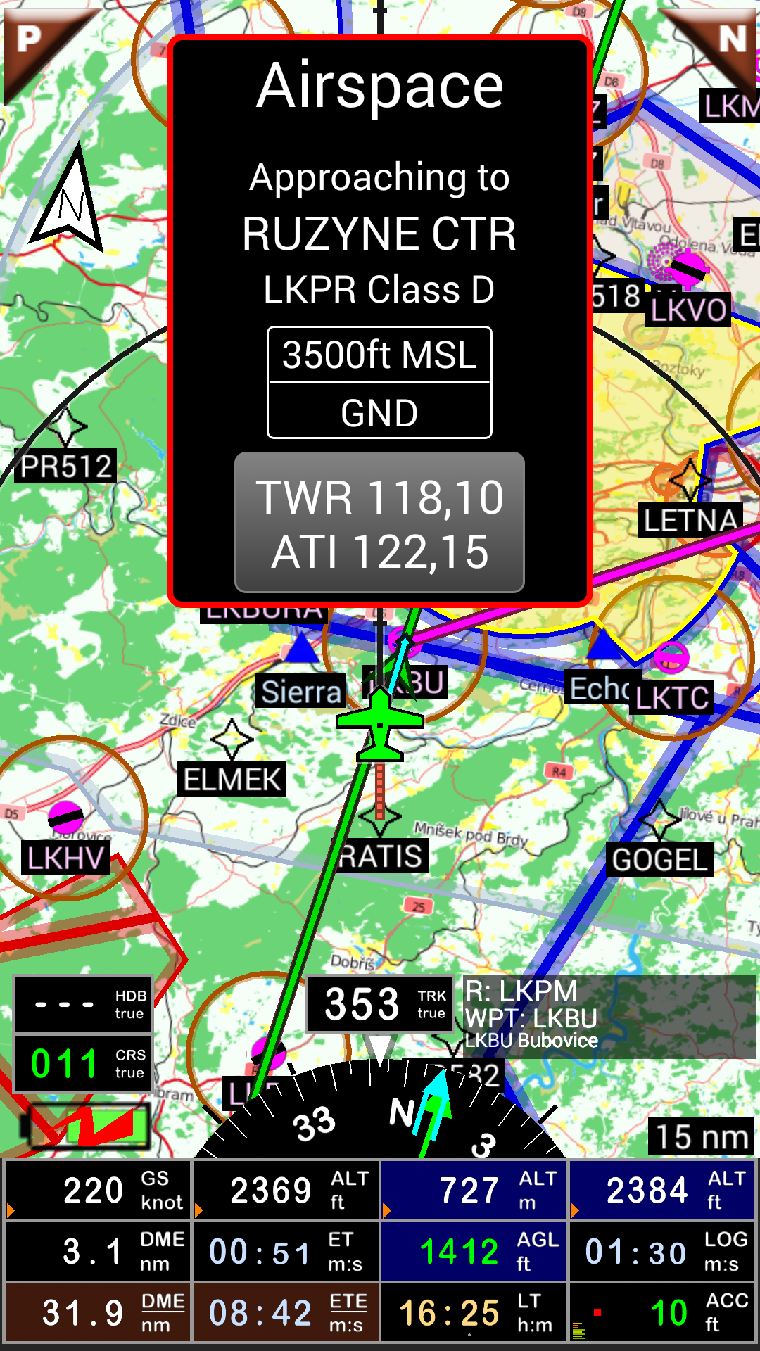
- Getting warnings, alarms and radio info before entering controlled or special use airspaces, approaching points
- Performing route planning, evaluating distance, time and fuel consumption (depending on wind and aircraft characteristics)
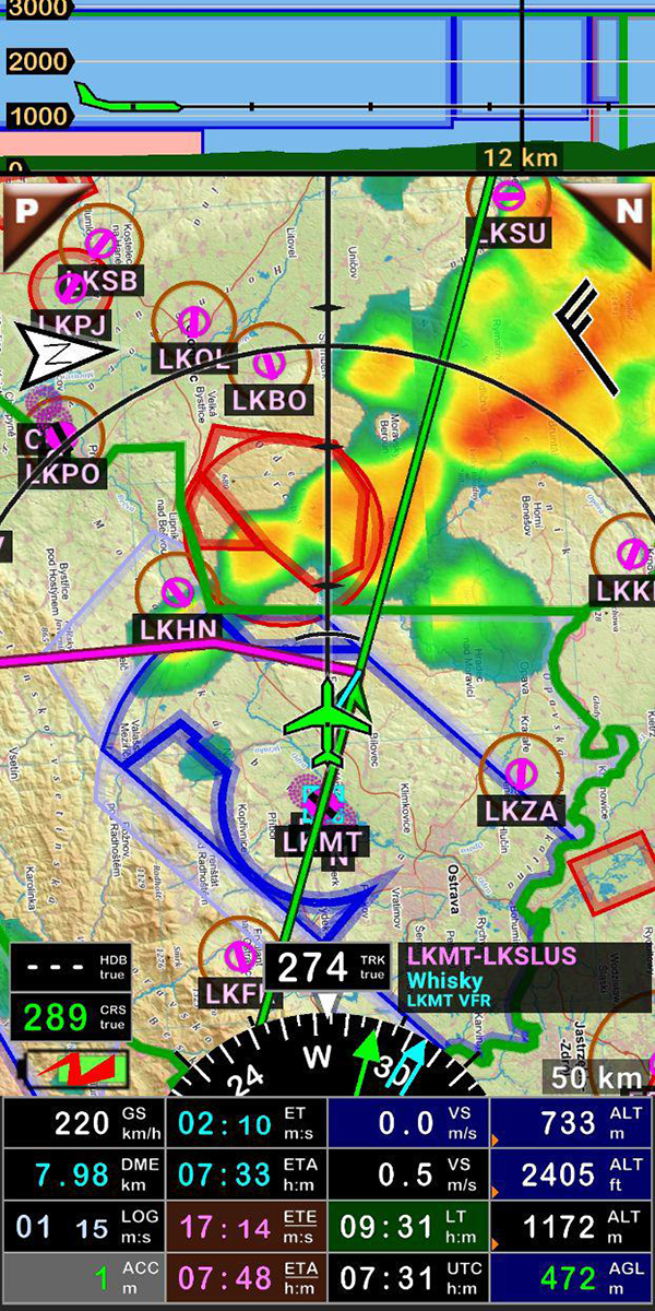
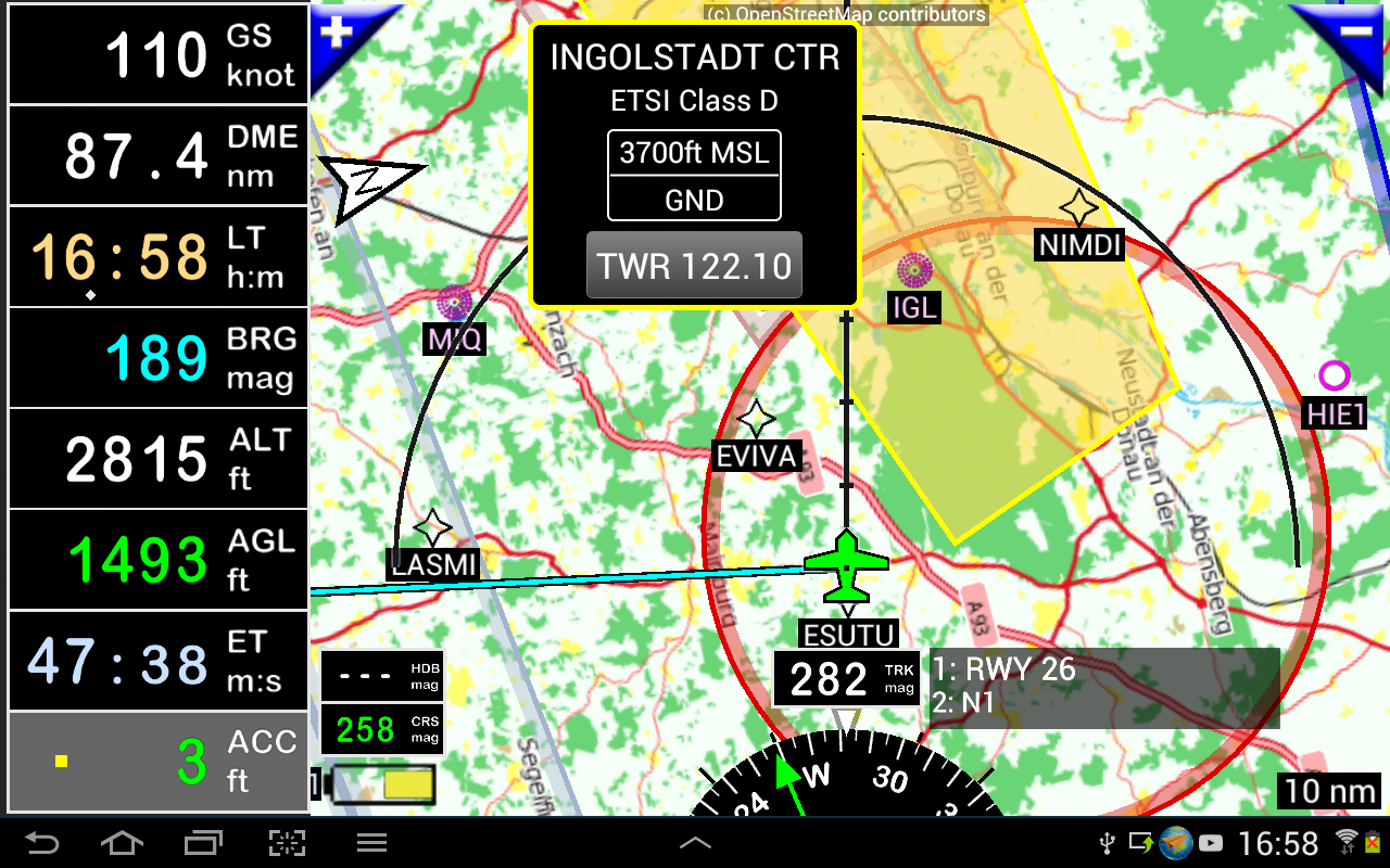
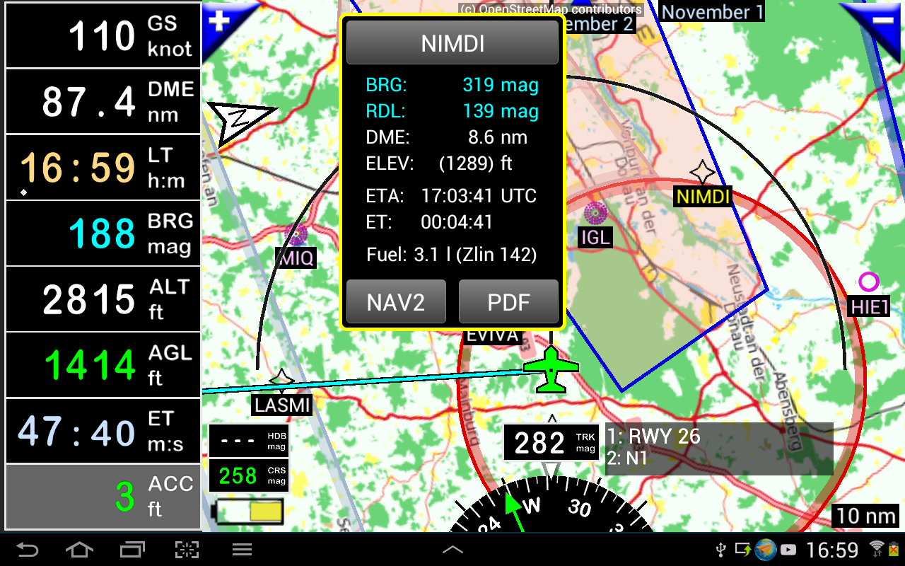
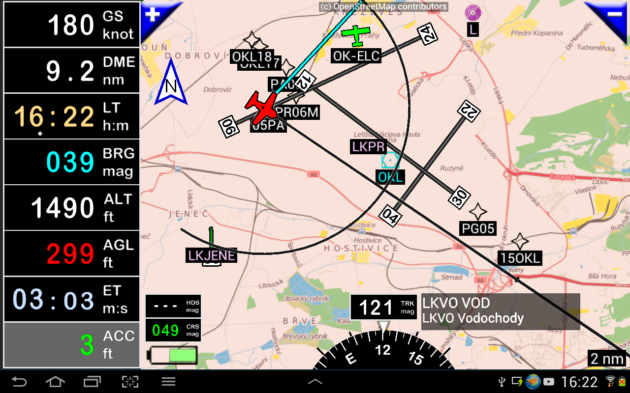
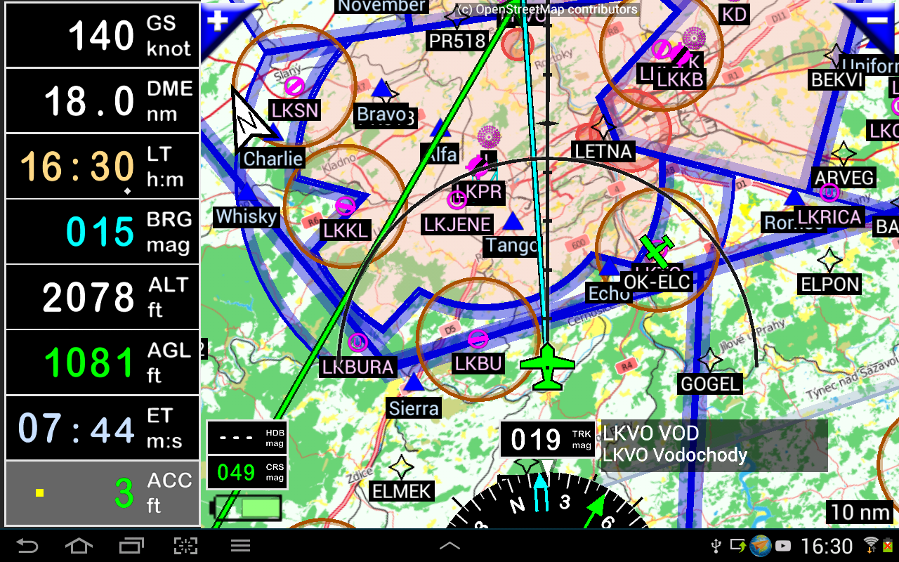
- Displaying route, bearing, trace on moving map
- Visualizing airspace
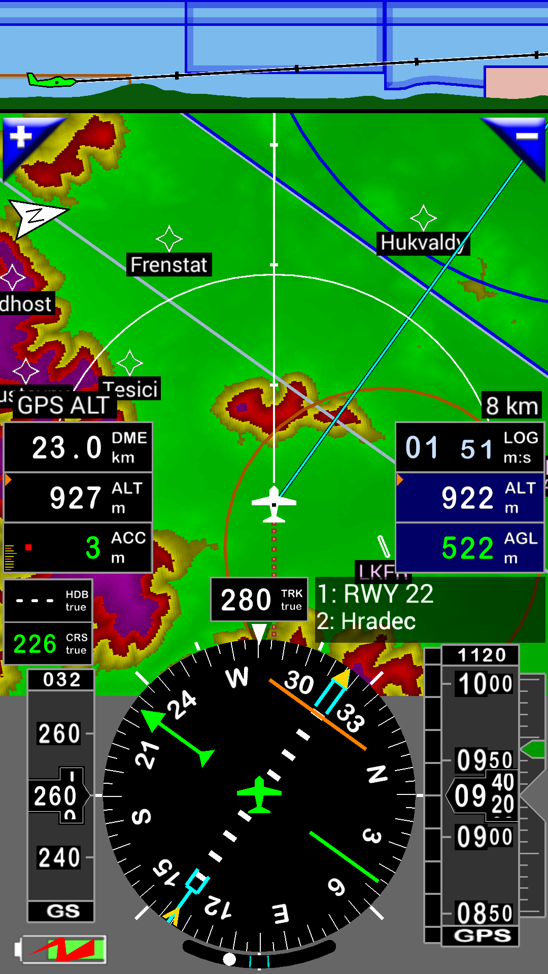
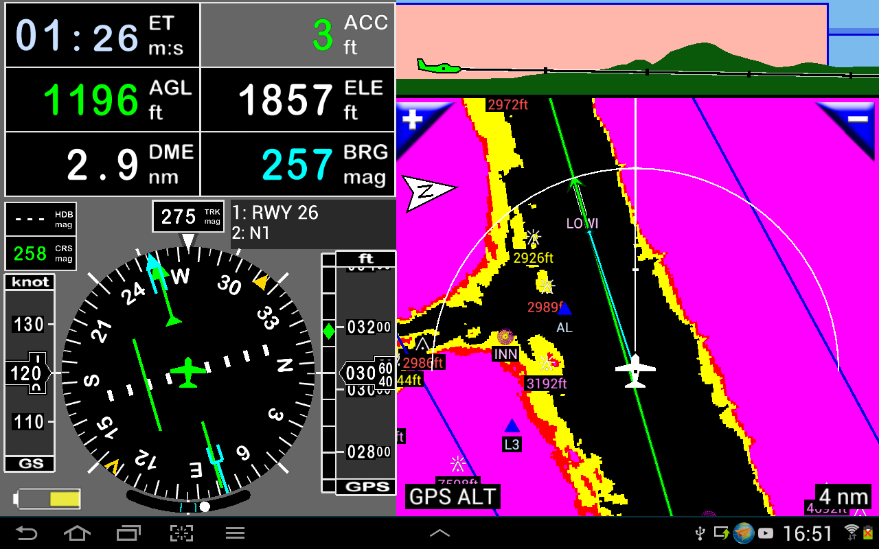
- Getting dynamic terrain map (colors depending of elevation above ground level)
- STRATUX support
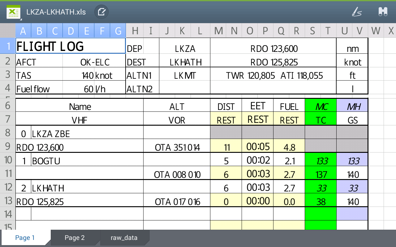
- Creating and exporting Flight Plan
- Creating and exporting Flight log
- Creating, importing or exporting routes, waypoints, RWY, airspace (Garmin .gpx, .kml, txt, OpenAir)
- Recording the flight and playing it back with Google Earth
- Sunset / Sunrise
- Getting weather forecast along the route
- Rainfall radar
- Wind displaying
- Calculating distance between 2 points on the map
- VACs
- Notepad
…
All main screens (5 portrait and 5 landscape could easily be customized. Pilot can choose from around 100 values to display. Example:
- Altitude GPS or barometric
- Ground speed
- Bearing
- Vertical speed
- DME to next point / destination
- Estimated time to next point / destination
- Time since departure
- Stop watch
…
Displayed information could be customized too depending of users preferences (VFR, IFR or both) and zoom level. The more you zoom IN, the more detail, information, waypoints,.. you see
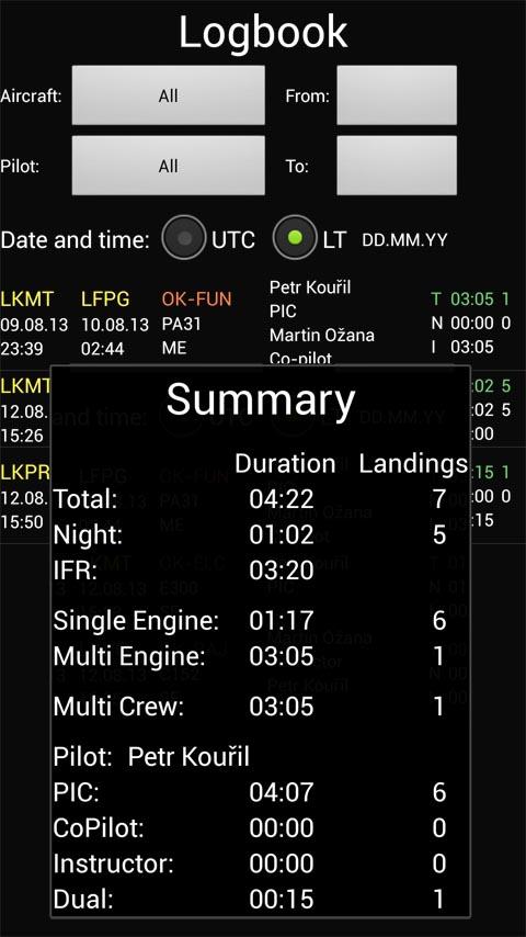
Logbook
The integrated logbook, allows recording:
- Duration since departure time
- Departure and arrival time
- Departure and arrival airport
- Flight track (it is possible to export it as .kml or .gpx and to replay it)
- Used aircraft
- Pilot(s) and copilots in charge
- Distance, average speed, maximum speed
…
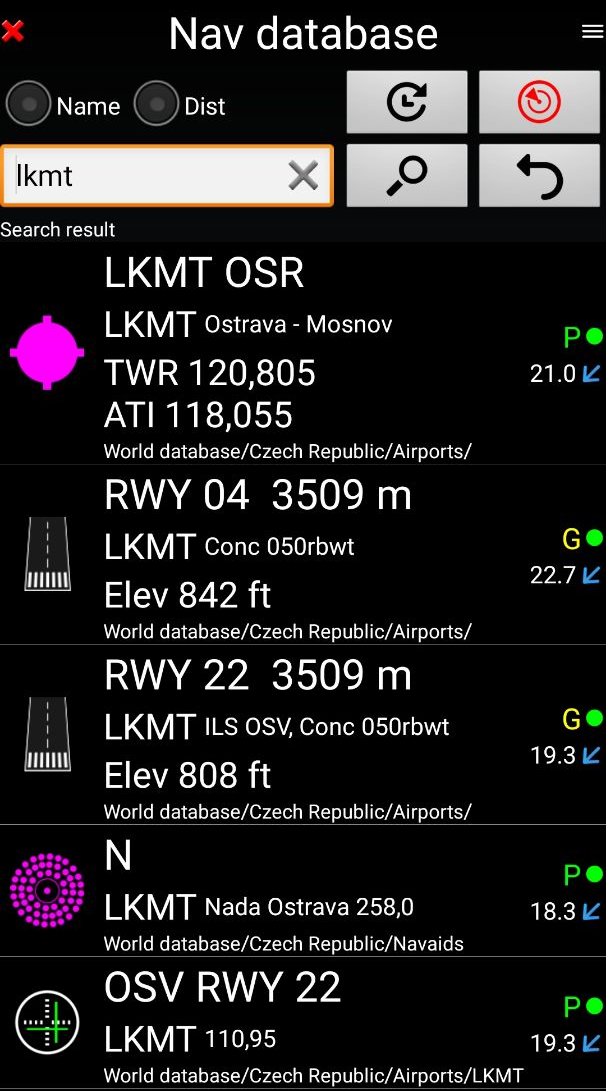
Navigation data available from open source database are updated according AIRAC cycles.
Charts and elevation dta
Free charts and elevation data are available for most of countries and could be imported directly via the application store.
Other charts could be created and imported by the pilot itself or made on request available as commercial service.
Pilots could select the most appropriate charts: free open source charts as well as commercial charts as ICAO, Cartabossy, SkyVector, FAA sectional and terminal charts…
VACs and PDF files
VAC and AIP infos are available for more than 50 countries
User can easily attach your own PDF files.
Usage of external GPS connected via Bluetooth is possible
User guide: http://www.funair.cz/downloads/manuals/flyisfun.pdf
If you have any suggestion to improve this application or you find some bug please visit www.flyisfun.com
Use this application for VFR FLYING ONLY!!! We are not responsible for any use of this application.
FLY is FUN simulates ILS approach, VOR, NDB, DME, Marker beacons, RNAV navigation and Marker beacons warnings, without ILS/VOR/NDB/RNAV equipment on board.
You can test FLY is FUN for free during few days. At the end of the trial period, pilot is invited to subscribe and pay an annual fees. Doing it, he get the right of using the application "as it is" and contribute to development effort.
FLY is FUN allows:
- Creating and modifying routes using "drag and drop", "rubber band"
- Getting warnings, alarms and radio info before entering controlled or special use airspaces, approaching points
- Performing route planning, evaluating distance, time and fuel consumption (depending on wind and aircraft characteristics)
- Displaying route, bearing, trace on moving map
- Visualizing airspace
- Getting dynamic terrain map (colors depending of elevation above ground level)
- STRATUX support
- Creating and exporting Flight Plan
- Creating and exporting Flight log
- Creating, importing or exporting routes, waypoints, RWY, airspace (Garmin .gpx, .kml, txt, OpenAir)
- Recording the flight and playing it back with Google Earth
- Sunset / Sunrise
- Getting weather forecast along the route
- Rainfall radar
- Wind displaying
- Calculating distance between 2 points on the map
- VACs
- Notepad
…
All main screens (5 portrait and 5 landscape could easily be customized. Pilot can choose from around 100 values to display. Example:
- Altitude GPS or barometric
- Ground speed
- Bearing
- Vertical speed
- DME to next point / destination
- Estimated time to next point / destination
- Time since departure
- Stop watch
…
Displayed information could be customized too depending of users preferences (VFR, IFR or both) and zoom level. The more you zoom IN, the more detail, information, waypoints,.. you see
Logbook
The integrated logbook, allows recording:
- Duration since departure time
- Departure and arrival time
- Departure and arrival airport
- Flight track (it is possible to export it as .kml or .gpx and to replay it)
- Used aircraft
- Pilot(s) and copilots in charge
- Distance, average speed, maximum speed
…
Navigation data available from open source database are updated according AIRAC cycles.
Charts and elevation dta
Free charts and elevation data are available for most of countries and could be imported directly via the application store.
Other charts could be created and imported by the pilot itself or made on request available as commercial service.
Pilots could select the most appropriate charts: free open source charts as well as commercial charts as ICAO, Cartabossy, SkyVector, FAA sectional and terminal charts…
VACs and PDF files
VAC and AIP infos are available for more than 50 countries
User can easily attach your own PDF files.
Usage of external GPS connected via Bluetooth is possible
User guide: http://www.funair.cz/downloads/manuals/flyisfun.pdf
If you have any suggestion to improve this application or you find some bug please visit www.flyisfun.com
Use this application for VFR FLYING ONLY!!! We are not responsible for any use of this application.
FLY is FUN 33.80 Update
- You can share/send all your settings. Menu / App settings / Preferences, General settings / Share preferences
- When you click at settings file with suffix .prefs (attached by email, chats like a Telegram) you can import all settings.
- You can share airspaces. Open airspaces, select desired airspaces and press share button. You can also easy import them by clicking on a KML or GIA or TXT (OpenAir) file
- When you click at settings file with suffix .prefs (attached by email, chats like a Telegram) you can import all settings.
- You can share airspaces. Open airspaces, select desired airspaces and press share button. You can also easy import them by clicking on a KML or GIA or TXT (OpenAir) file
Read More
Related Videos

Previous Versions More
FLY is FUN Aviation Navigation
33.80
APK
November 8, 2024
35.38 MB
Requires Android: Android 5.0+
Architecture: arm64-v8a, armeabi-v7a, mips, mips64, x86, x86_64
Screen DPI: 160-640dpi
SHA1: d97a462b77f452786544d5020b42888a695a20a2
Size: 35.38 MB
What's New:
- You can share/send all your settings. Menu / App settings / Preferences, General settings / Share preferences
- When you click at settings file with suffix .prefs (attached by email, chats like a Telegram) you can import all settings.
- You can share airspaces. Open airspaces, select desired airspaces and press share button. You can also easy import them by clicking on a KML or GIA or TXT (OpenAir) file
- When you click at settings file with suffix .prefs (attached by email, chats like a Telegram) you can import all settings.
- You can share airspaces. Open airspaces, select desired airspaces and press share button. You can also easy import them by clicking on a KML or GIA or TXT (OpenAir) file
FLY is FUN Aviation Navigation
33.72
APK
October 23, 2024
35.37 MB
Requires Android: Android 5.0+
Architecture: arm64-v8a, armeabi-v7a, mips, mips64, x86, x86_64
Screen DPI: 160-640dpi
SHA1: 6c6a9b00e940c34baddbfe4aa3ac97caee843ce4
Size: 35.37 MB
What's New:
Removed bug: When app uses the external data (GDL90, ...) the The ACC window could display nonsensical values.
FLY is FUN Aviation Navigation
33.70
APK
September 28, 2024
35.37 MB
Requires Android: Android 5.0+
Architecture: arm64-v8a, armeabi-v7a, mips, mips64, x86, x86_64
Screen DPI: 160-640dpi
SHA1: 7d8db93bd217a532673cb21ee8aedac67a7546d8
Size: 35.37 MB
What's New:
- You can select require fuel to NAV2 (screen customize)
- Removed bug, inverting route WPTs
- Removed bug, inverting route WPTs
FLY is FUN Aviation Navigation
33.60
APK
August 20, 2024
35.37 MB
Requires Android: Android 5.0+
Architecture: arm64-v8a, armeabi-v7a, mips, mips64, x86, x86_64
Screen DPI: 160-640dpi
SHA1: 7e1dbcc24d7ac57528acdac0c624f42d1f056490
Size: 35.37 MB
What's New:
- Broadcasting NMEA - added GSA sentence
- External data - now it is possible to use NMEA location from external sources using WiFi connection (UDP protocol).
- Nearest object dlg shows ATIS frequency if available
- You can select alternate airport when you create a route using map.
- When you select ILS approach from RWY item (open nav database, find desired RWY, click on RWY icon and select ILS approach), app remembers the last values (glide slope angle, RWY threshold height)
More Information
Package Name:
Category:
Update Date:
2024-11-08
Latest Version:
33.80
Need Update:
Available on:
Requirements:
Android 5.0+
Report:
Alternatives to FLY is FUN
RWY by OzRunways
RWY by OzRunways is the most complete and easiest to use Electronic Flight Bag.
6.2 105
SkyDemon
SkyDemon is Europe's leading VFR flight-planning and GPS navigation software.
8.2 188
Air Navigation Pro
Fly safely and easily with our flight planning & real time navigation app!
7.0 306
UAV Forecast for Drone Pilots
Weather, GPS satellites, solar activity (Kp), No-Fly Zones and FAA TFRs
5.6 943
AirData UAV
Automatically capture your drone flights and discover early signs of problems
8.4 33