- Home
- Apps
- Travel & Local
- i-Boating:Marine Navigation
i-Boating:Marine Navigation
1K+ TRUSTED APP
v257.0 by Gps Nautical Charts


About i-Boating
i-Boating (Package Name: com.skiracer.nautical_astore_lite) is developed by Gps Nautical Charts and the latest version of i-Boating:Marine Navigation 257.0 was updated on August 14, 2024. i-Boating:Marine Navigation is in the category of Travel & Local with the feature Maps & Navigation. You can check all apps from the developer of i-Boating:Marine Navigation and find 200 alternative apps to i-Boating:Marine Navigation on Android. Currently this app is for free. This app can be downloaded on Android 4.0+ on APKPure.fo or Google Play. All APK/XAPK files on APKPure.fo are original and 100% safe with fast download.
This Marine Charts App offers offline nautical charts, inland river navigation charts, and lake contour maps for fishing,kayaking, yachting & sailing.
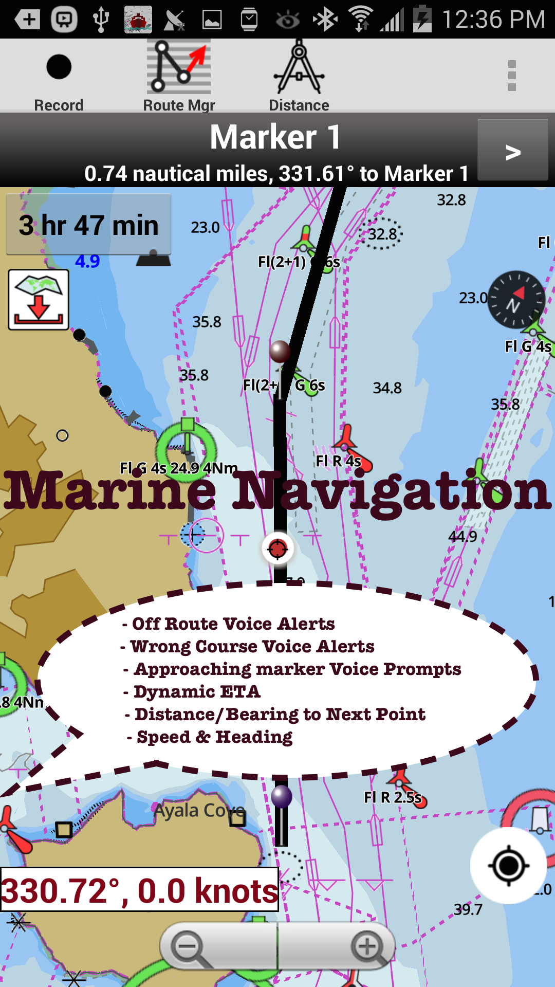
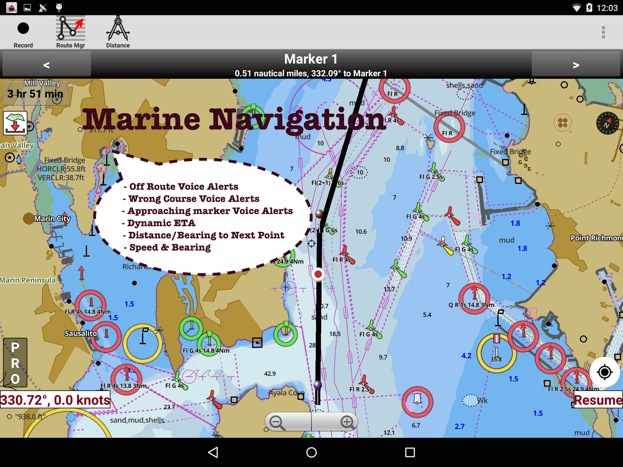
First marine navigation app to have boat route assistance with Voice Prompts. All features of a Marine Chart plotter in one app!
It supports Nautical Charts course up orientation. Incl Tide Charts & Currents prediction for nautical navigation.
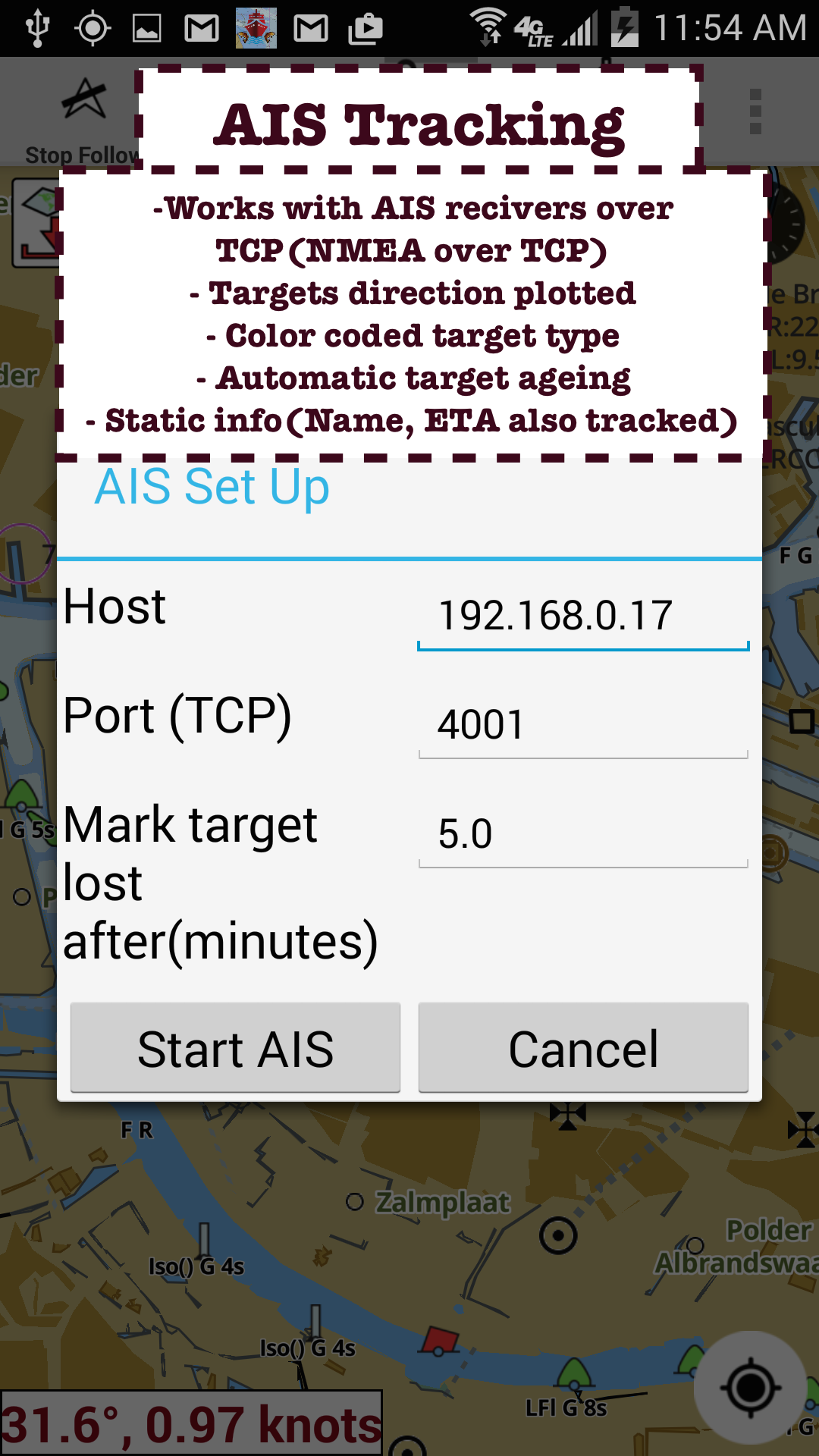
Create new boat routes / Waypoints, or import existing GPX/KML routes on device. Has Marine AIS(NMEA) support.
►FEATURES
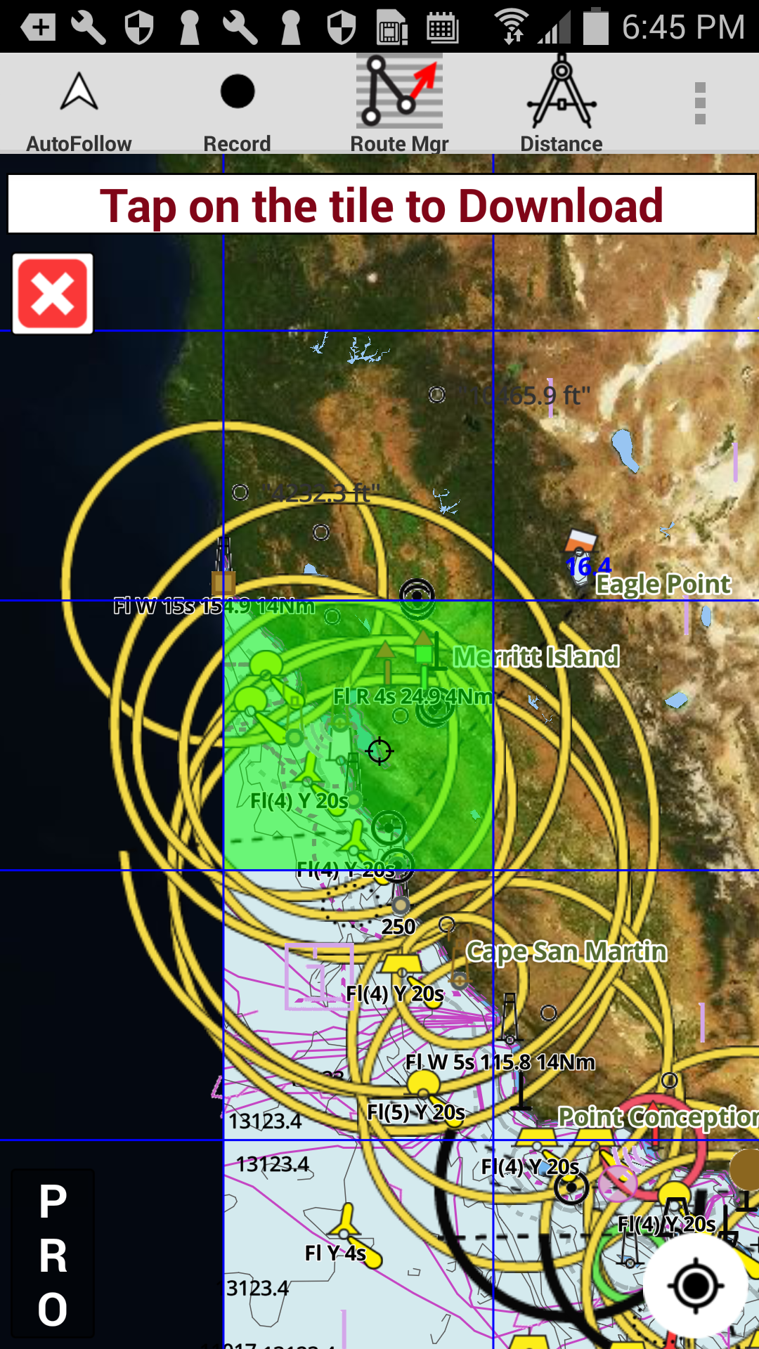
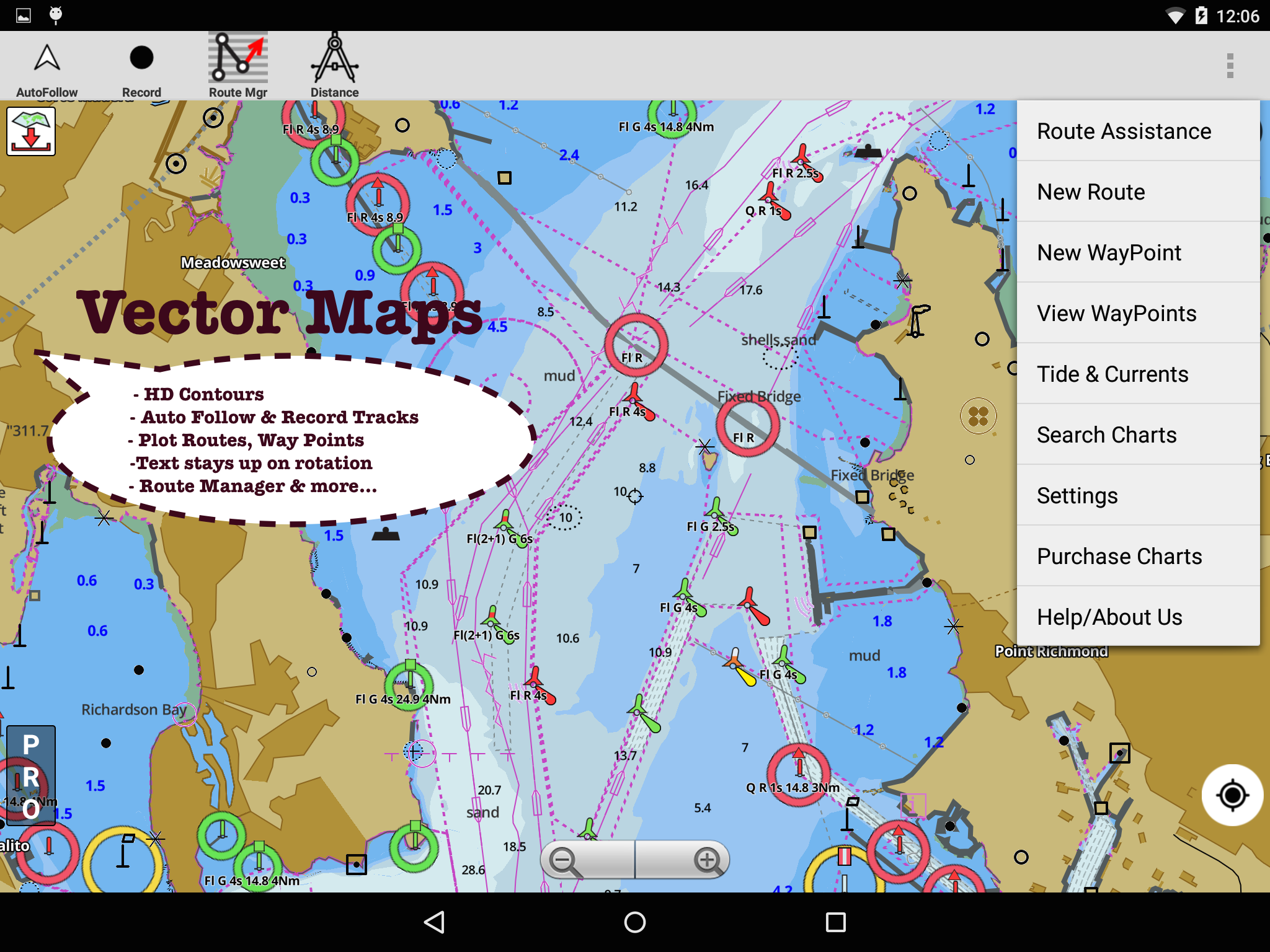
√ GPU accelerated offline vector NOAA charts/ENC charts (text stays upright on rotation)
√ Lake depth map shading/safety lake depth contours:custom boat safety depth
√ Maritime Aids to Boat Navigation : Beacons,Buoys,Boat Launch areas,Boat Ramps,Marina, Fishing Attractors
√ Record marine tracks, Autofollow with real-time track overlay
√ Voice Prompts for marine navigation
√ HD 1ft/3ft depth lake contour maps for anglers for selected lake maps: for fishing/trolling(freshwater/saltwater).
√ GPX/KML for boat route.
√ Seamless marine chart quilting: Details from Coastal, Approaches,Harbour & Inland ENC (Electronic Marine Charts)
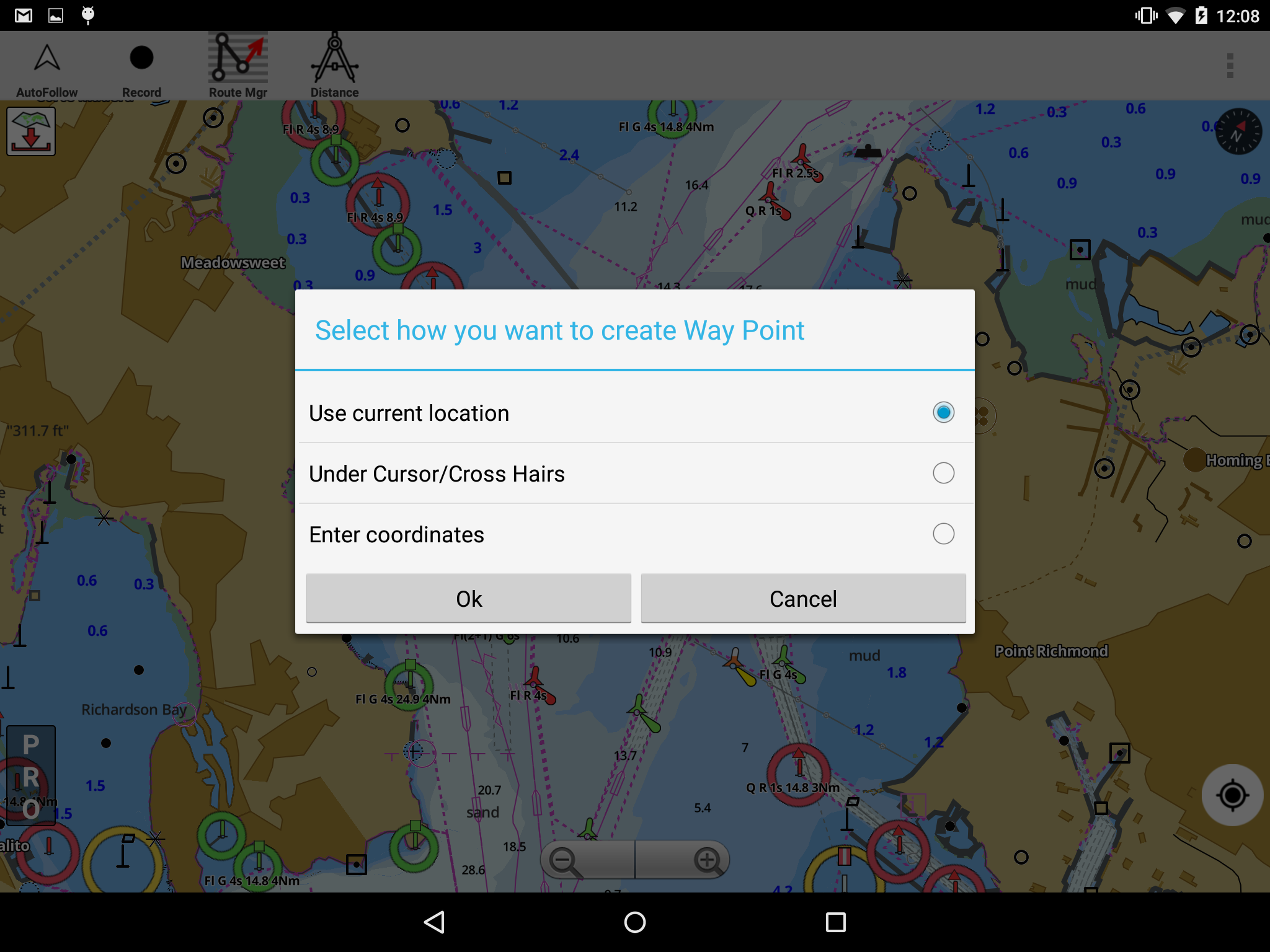
√ Waypoints
√ Tide & Currents.
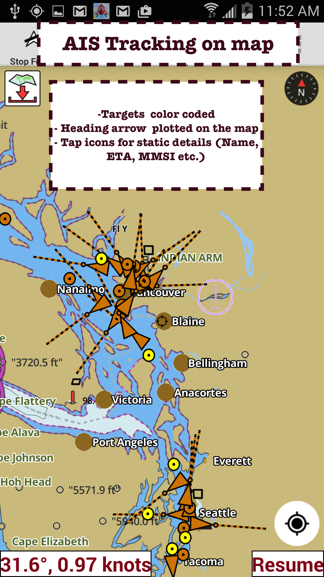
√ Marine AIS
√ Anchor Alarm
√ Magnify Text & Icons
√ Wind Prediction Overlay
√ Bearing True/Magnetic
► Fishing Hot Spots AI
► Lake Temperature Maps(Thermoclines accurate to 1°F (0.5° C)
► Relief Shading
► MAPS
All details of marine chartplotters!
Unlimited updates for 1 year.
USA: Maps incl coverage of NOAA marine charts,ENC,USACE inland river maps & freshwater lake bathymetry maps for more than 50K lakes. Charts incl HD/1ft bathymetry for selected lakes. Incl NOAA marine charts(rasters) w/ NOAA ENC coverage.
Canada:CHS data Incl Great lakes(US & Canada sides),Alberta & Ontario lakes,Lake Simcoe&Trent Severn Canal,Quebec reservoirs.
UK/Ireland: UKHO marine charts
Germany:BSH charts,Waterways & rivers.
France
Europe Inland Rivers:Donau/Danube/Dunaja,Rhine,Rhein,Garonne,Moselle,Drava,Sava
Australia
Netherland/Holland
Croatia
Finland
Norway
Sweden
Brazil
Spain
Malta,Cypress, Mediterranean Sea
Caribbean
New Zealand
Denmark,Greenland,Faroe
Seychelles,Mauritius,Tanzania
Falklands
Malaysia,South China Sea
Persian/Arabian Gulf,Red Sea
South Africa
Argentina
Iceland
Fiji
Estonia,Latvia,Poland,Lithuania
Turkey,Greece,Italy
►Instrumentation
√ Marine AIS & (NMEA AIS and GPS - TCP/UDP)
√ Wind direction & Speed,Marine Sonar depth,Water temperature
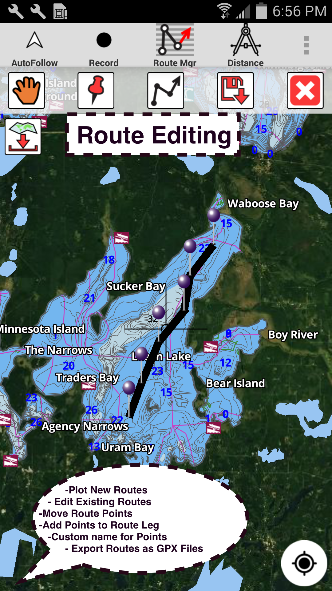
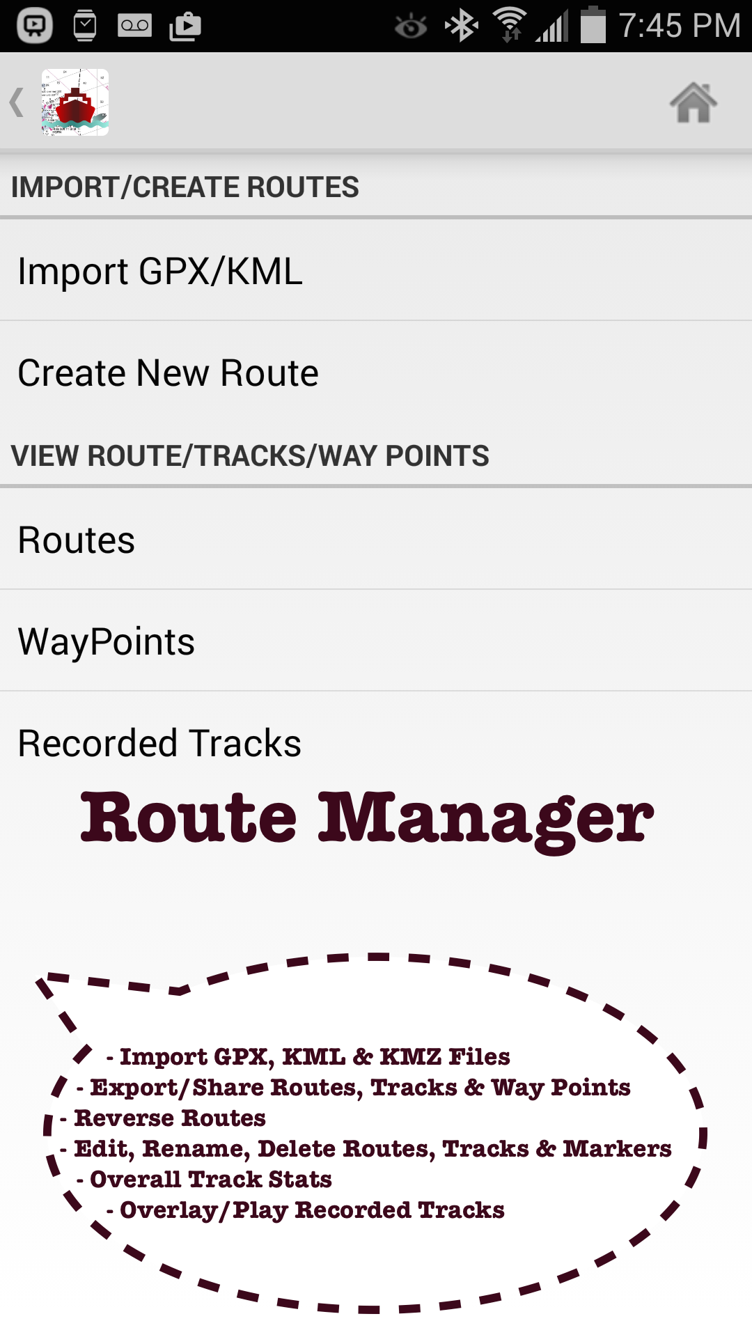
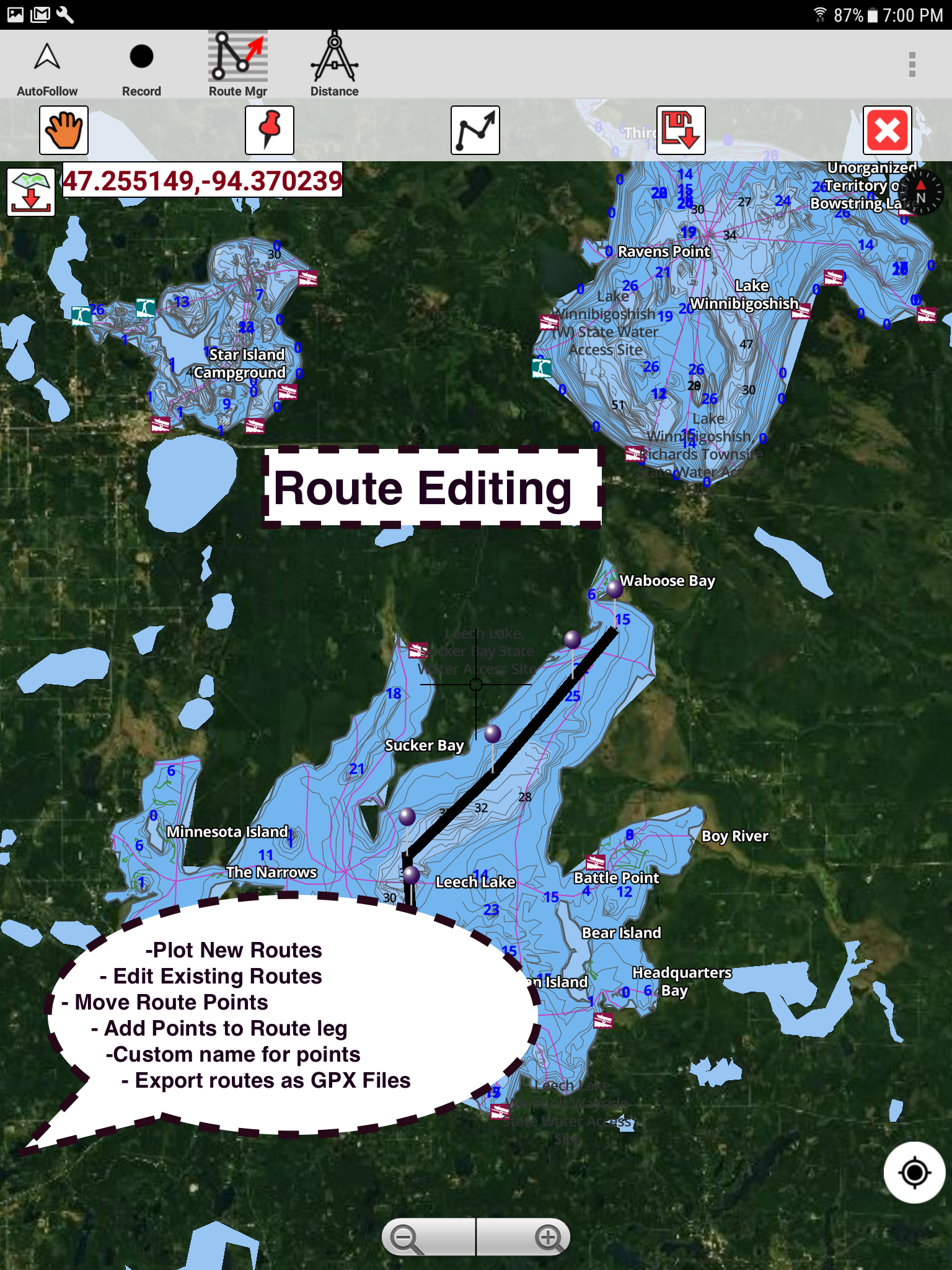
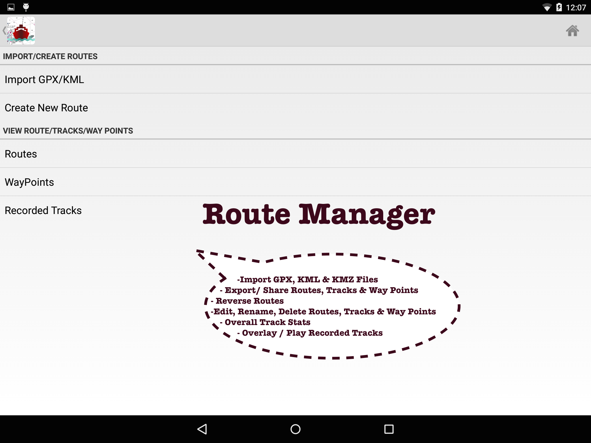
►ROUTE MANAGEMENT/TRIP PLANNING
√ Create/Edit/Reverse Boat Routes
√ Waypoints mgt
√ Import GPX,KML & KMZ files
√ Share/Export Routes,Boating log,Tracks&Markers
►FEATURES for BOAT NAVIGATION
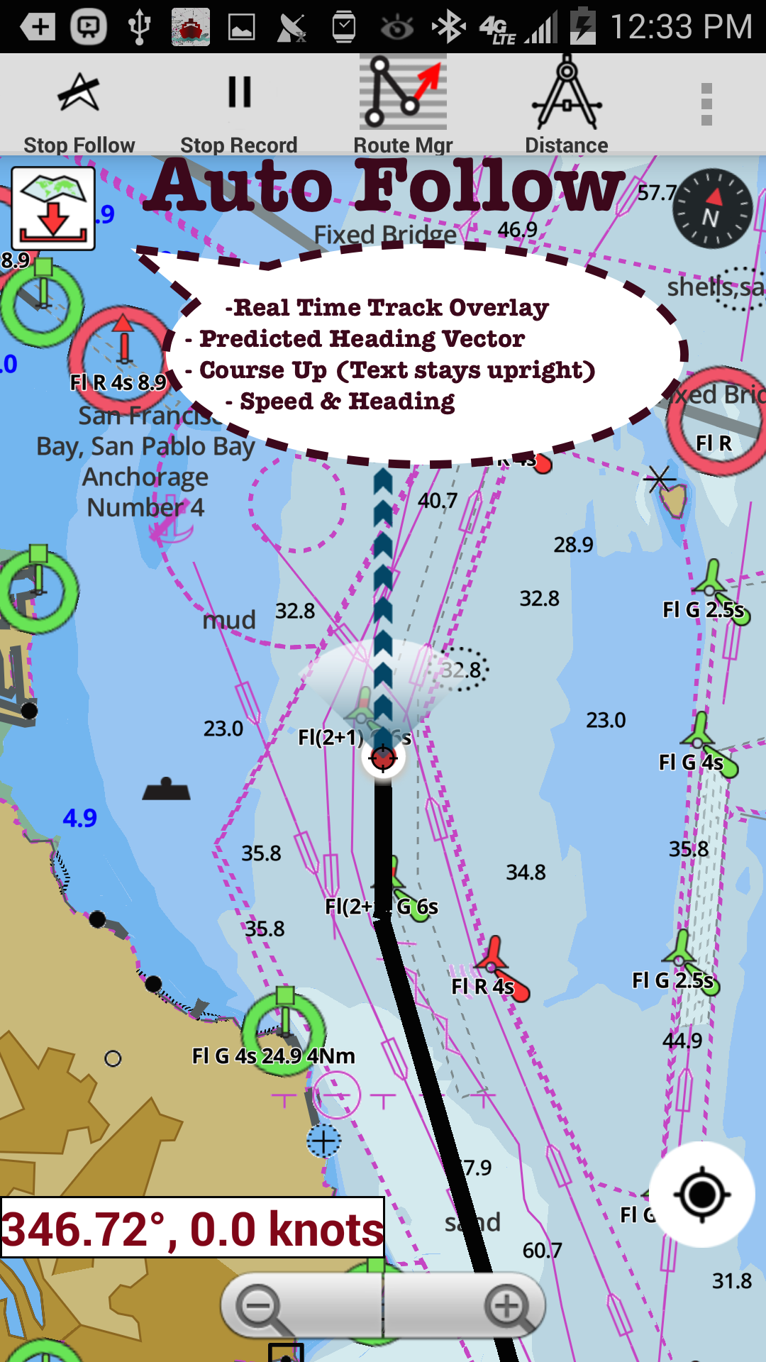
√ Auto Follow
* Real Time Overlay & Predicted Path Vector
* Course Up
* Speed & Heading
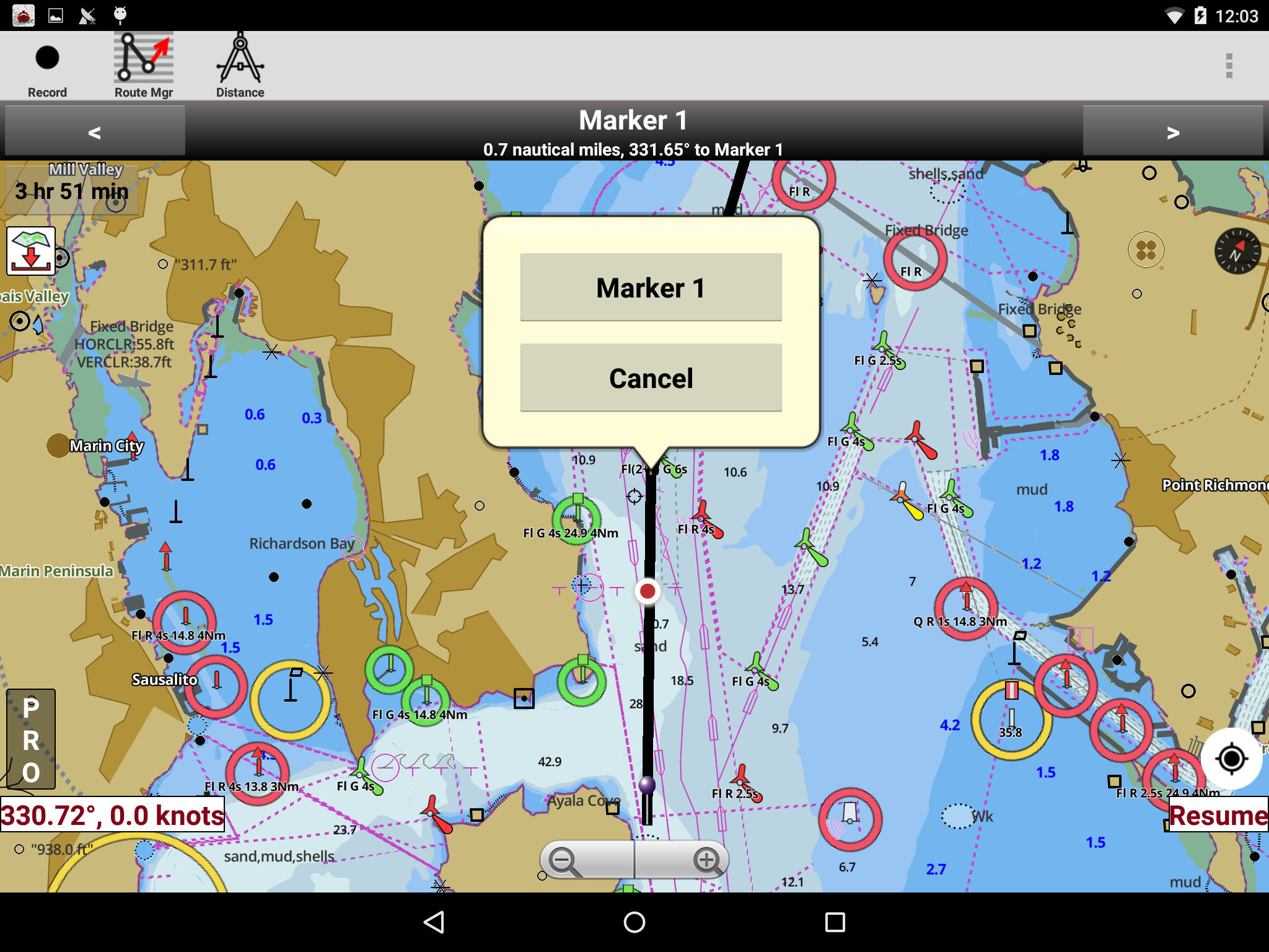
√ Route Assistance With Voice Prompts
* approaching boating route marker prompt
* Real time nautical distance & ETA
* sailing/boating off route/wrong direction
√ Record Tracks
►TIDE & CURRENTS
* High/Low Tides
* Tidal Current Prediction
►Marine Weather
*GFS + ECMWF
► SHARING
* Tracks/Boat routes/markers/Waypoints
* Export GPX.
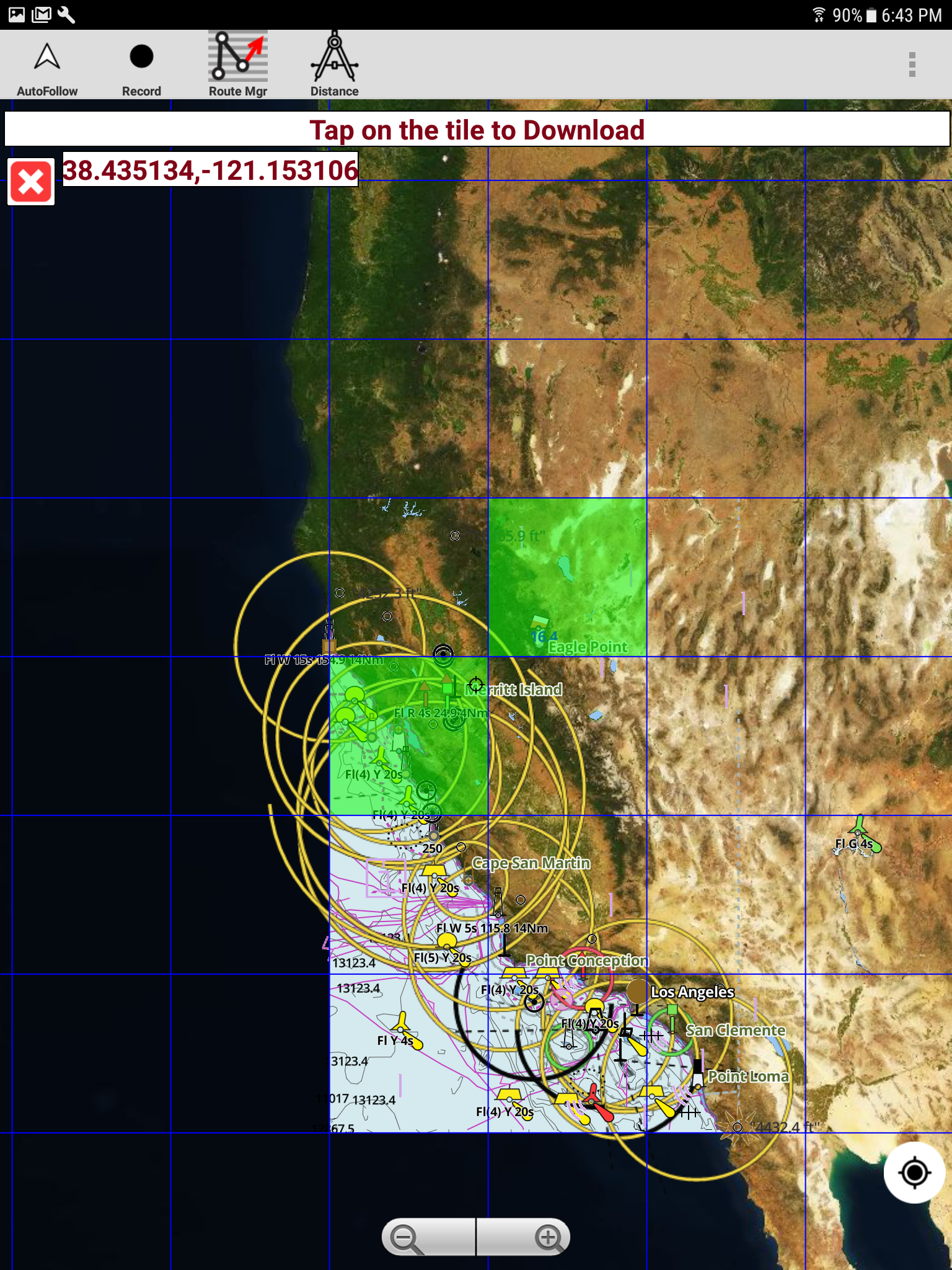
► Satellite Imagery
► USA Marine Charts
*Texas Lakes: Texoma,Eufaula,Toledo Bend
*California Lakes:Tahoe,Shasta
Pennsylvania Lakes: Raystown
Florida Lakes: Okeechobee,Kissimmee
*Minnesota Lakes: Minnetonka,Waconia,Leech,Mille Lacs
* Massachussets lakes Quabbin
*Missouri Lakes: Truman
*Ohio Lake maps Lake hoover
*Wisconsin Lakes: Winnebago,Pepin
* Utah Lake Powell,Bear
*Maine Lake Sebago
*Alaska Lakes:Winnipesaukee
*Tennessee Lake Barkley,Norris,Watts Bar
*South Carolina Lake Keowee,Hartwell,Murray
*Lake Michigan,Huron,Ontario,Superior,Erie
►Canada Lakes Maps
*Lac Saint Jean
*Ontario Lake depth maps
*Rideau Canal-Ottawa River
*British Columbia Marine Charts
*Pacific Coast-Vancouver- Haida Gwaii
*Nova Scotia South-Bay of Fundy
*Quebec-Anticosti Island
*Newfoundland
*St. Lawrence river
*Manitoba & Saskatchewan
*Georgian Bay
*Puget Sound
►UK Nautical Charts
*Scotland
*Thames Estuary
*Ireland
►Australia Marine & Lake Maps
*NSW
*Queensland
First marine navigation app to have boat route assistance with Voice Prompts. All features of a Marine Chart plotter in one app!
It supports Nautical Charts course up orientation. Incl Tide Charts & Currents prediction for nautical navigation.
Create new boat routes / Waypoints, or import existing GPX/KML routes on device. Has Marine AIS(NMEA) support.
►FEATURES
√ GPU accelerated offline vector NOAA charts/ENC charts (text stays upright on rotation)
√ Lake depth map shading/safety lake depth contours:custom boat safety depth
√ Maritime Aids to Boat Navigation : Beacons,Buoys,Boat Launch areas,Boat Ramps,Marina, Fishing Attractors
√ Record marine tracks, Autofollow with real-time track overlay
√ Voice Prompts for marine navigation
√ HD 1ft/3ft depth lake contour maps for anglers for selected lake maps: for fishing/trolling(freshwater/saltwater).
√ GPX/KML for boat route.
√ Seamless marine chart quilting: Details from Coastal, Approaches,Harbour & Inland ENC (Electronic Marine Charts)
√ Waypoints
√ Tide & Currents.
√ Marine AIS
√ Anchor Alarm
√ Magnify Text & Icons
√ Wind Prediction Overlay
√ Bearing True/Magnetic
► Fishing Hot Spots AI
► Lake Temperature Maps(Thermoclines accurate to 1°F (0.5° C)
► Relief Shading
► MAPS
All details of marine chartplotters!
Unlimited updates for 1 year.
USA: Maps incl coverage of NOAA marine charts,ENC,USACE inland river maps & freshwater lake bathymetry maps for more than 50K lakes. Charts incl HD/1ft bathymetry for selected lakes. Incl NOAA marine charts(rasters) w/ NOAA ENC coverage.
Canada:CHS data Incl Great lakes(US & Canada sides),Alberta & Ontario lakes,Lake Simcoe&Trent Severn Canal,Quebec reservoirs.
UK/Ireland: UKHO marine charts
Germany:BSH charts,Waterways & rivers.
France
Europe Inland Rivers:Donau/Danube/Dunaja,Rhine,Rhein,Garonne,Moselle,Drava,Sava
Australia
Netherland/Holland
Croatia
Finland
Norway
Sweden
Brazil
Spain
Malta,Cypress, Mediterranean Sea
Caribbean
New Zealand
Denmark,Greenland,Faroe
Seychelles,Mauritius,Tanzania
Falklands
Malaysia,South China Sea
Persian/Arabian Gulf,Red Sea
South Africa
Argentina
Iceland
Fiji
Estonia,Latvia,Poland,Lithuania
Turkey,Greece,Italy
►Instrumentation
√ Marine AIS & (NMEA AIS and GPS - TCP/UDP)
√ Wind direction & Speed,Marine Sonar depth,Water temperature
►ROUTE MANAGEMENT/TRIP PLANNING
√ Create/Edit/Reverse Boat Routes
√ Waypoints mgt
√ Import GPX,KML & KMZ files
√ Share/Export Routes,Boating log,Tracks&Markers
►FEATURES for BOAT NAVIGATION
√ Auto Follow
* Real Time Overlay & Predicted Path Vector
* Course Up
* Speed & Heading
√ Route Assistance With Voice Prompts
* approaching boating route marker prompt
* Real time nautical distance & ETA
* sailing/boating off route/wrong direction
√ Record Tracks
►TIDE & CURRENTS
* High/Low Tides
* Tidal Current Prediction
►Marine Weather
*GFS + ECMWF
► SHARING
* Tracks/Boat routes/markers/Waypoints
* Export GPX.
► Satellite Imagery
► USA Marine Charts
*Texas Lakes: Texoma,Eufaula,Toledo Bend
*California Lakes:Tahoe,Shasta
Pennsylvania Lakes: Raystown
Florida Lakes: Okeechobee,Kissimmee
*Minnesota Lakes: Minnetonka,Waconia,Leech,Mille Lacs
* Massachussets lakes Quabbin
*Missouri Lakes: Truman
*Ohio Lake maps Lake hoover
*Wisconsin Lakes: Winnebago,Pepin
* Utah Lake Powell,Bear
*Maine Lake Sebago
*Alaska Lakes:Winnipesaukee
*Tennessee Lake Barkley,Norris,Watts Bar
*South Carolina Lake Keowee,Hartwell,Murray
*Lake Michigan,Huron,Ontario,Superior,Erie
►Canada Lakes Maps
*Lac Saint Jean
*Ontario Lake depth maps
*Rideau Canal-Ottawa River
*British Columbia Marine Charts
*Pacific Coast-Vancouver- Haida Gwaii
*Nova Scotia South-Bay of Fundy
*Quebec-Anticosti Island
*Newfoundland
*St. Lawrence river
*Manitoba & Saskatchewan
*Georgian Bay
*Puget Sound
►UK Nautical Charts
*Scotland
*Thames Estuary
*Ireland
►Australia Marine & Lake Maps
*NSW
*Queensland
i-Boating 257.0 Update
MAJOR UPDATE:ECMWF Weather
RELIEF SHADING
Lake Temperature
Marine Weather Forecast
Fishing AI
NMEA ALARMS:Depth+Wind
Marine Weather:Wind,Wave
Automatic Boat Routing
-UK Tide & Currents
-Magnetic Bearing
-Wind Prediction Overlay
-Magnify Text+Icons
-Anchor alarm
- Auto Pilot
-Custom depth shading
-Satellite imagery
-AIS &GPS NMEA TCP/UDP
-Russian rivers(Volga)
-Wind speed,direction,sonar depth,water temp
Norway,Finland,Denmark
German(Donau,Elbe,Mosel,Rhein,Saar,Weser)
Elbe,Ruhr
Read More
Related Videos

Previous Versions More
i-Boating:Marine Navigation
257.0
APK
August 16, 2024
25.87 MB
Requires Android: Android 4.0+
Architecture: arm64-v8a, armeabi, armeabi-v7a, mips, x86, x86_64
Screen DPI: 120-640dpi
SHA1: 0b9e9446ed050deed49f3ccb7a91f0453c4491b8
Size: 25.87 MB
What's New:
MAJOR UPDATE:ECMWF Weather
RELIEF SHADING
Lake Temperature
Marine Weather Forecast
Fishing AI
NMEA ALARMS:Depth+Wind
Marine Weather:Wind,Wave
Automatic Boat Routing
-UK Tide & Currents
-Magnetic Bearing
-Wind Prediction Overlay
-Magnify Text+Icons
-Anchor alarm
- Auto Pilot
-Custom depth shading
-Satellite imagery
-AIS &GPS NMEA TCP/UDP
-Russian rivers(Volga)
-Wind speed,direction,sonar depth,water temp
Norway,Finland,Denmark
German(Donau,Elbe,Mosel,Rhein,Saar,Weser)
Elbe,Ruhr
RELIEF SHADING
Lake Temperature
Marine Weather Forecast
Fishing AI
NMEA ALARMS:Depth+Wind
Marine Weather:Wind,Wave
Automatic Boat Routing
-UK Tide & Currents
-Magnetic Bearing
-Wind Prediction Overlay
-Magnify Text+Icons
-Anchor alarm
- Auto Pilot
-Custom depth shading
-Satellite imagery
-AIS &GPS NMEA TCP/UDP
-Russian rivers(Volga)
-Wind speed,direction,sonar depth,water temp
Norway,Finland,Denmark
German(Donau,Elbe,Mosel,Rhein,Saar,Weser)
Elbe,Ruhr
i-Boating:Marine Navigation
254.0
APK
July 9, 2024
25.87 MB
Requires Android: Android 4.0+
Architecture: arm64-v8a, armeabi, armeabi-v7a, mips, x86, x86_64
Screen DPI: 120-640dpi
SHA1: a30f5886894692bad6185fe7725dfebd93cf0f90
Size: 25.87 MB
What's New:
MAJOR UPDATE:ECMWF Weather
RELIEF SHADING
Lake Temperature
Marine Weather Forecast
Fishing AI
NMEA ALARMS:Depth+Wind
Marine Weather:Wind,Wave
Automatic Boat Routing
-UK Tide & Currents
-Magnetic Bearing
-Wind Prediction Overlay
-Magnify Text+Icons
-Anchor alarm
- Auto Pilot
-Custom depth shading
-Satellite imagery
-AIS &GPS NMEA TCP/UDP
-Russian rivers(Volga)
-Wind speed,direction,sonar depth,water temp
Norway,Finland,Denmark
German(Donau,Elbe,Mosel,Rhein,Saar,Weser)
Elbe,Ruhr
RELIEF SHADING
Lake Temperature
Marine Weather Forecast
Fishing AI
NMEA ALARMS:Depth+Wind
Marine Weather:Wind,Wave
Automatic Boat Routing
-UK Tide & Currents
-Magnetic Bearing
-Wind Prediction Overlay
-Magnify Text+Icons
-Anchor alarm
- Auto Pilot
-Custom depth shading
-Satellite imagery
-AIS &GPS NMEA TCP/UDP
-Russian rivers(Volga)
-Wind speed,direction,sonar depth,water temp
Norway,Finland,Denmark
German(Donau,Elbe,Mosel,Rhein,Saar,Weser)
Elbe,Ruhr
i-Boating:Marine Navigation
249.0
APK
May 20, 2024
25.71 MB
Requires Android: Android 4.0+
Architecture: arm64-v8a, armeabi, armeabi-v7a, mips, x86, x86_64
Screen DPI: 120-640dpi
SHA1: 30bdeafa3236c590c51ea8d9afc9761875167f54
Size: 25.71 MB
What's New:
MAJOR UPDATE: RELIEF SHADING
Lake Temperature
Marine Weather Forecast
Fishing AI
NMEA ALARMS:Depth+Wind
Marine Weather:Wind,Wave
Automatic Boat Routing
-UK Tide & Currents
-Magnetic Bearing
-Wind Prediction Overlay
-Magnify Text+Icons
-Anchor alarm
- Auto Pilot
-Greenland
-Custom depth shading
-Satellite imagery
-AIS &GPS NMEA TCP/UDP
-Russian rivers(Volga)
-Wind speed,direction,sonar depth,water temp
Norway,Finland,Denmark
German(Donau,Elbe,Mosel,Rhein,Saar,Weser)
Elbe,Ruhr,Mosel,Saar
i-Boating:Marine Navigation
243.0
APK
April 27, 2024
25.71 MB
Requires Android: Android 4.0+
Architecture: arm64-v8a, armeabi, armeabi-v7a, mips, x86, x86_64
Screen DPI: 120-640dpi
SHA1: 1500148085a980eff3b86888d8594b266e00cef9
Size: 25.71 MB
What's New:
MAJOR UPDATE: RELIEF SHADING
Lake Temperature
Marine Weather Forecast
Fishing AI
NMEA ALARMS:Depth+Wind
Marine Weather:Wind,Wave
Automatic Boat Routing
-UK Tide & Currents
-Magnetic Bearing
-Wind Prediction Overlay
-Magnify Text+Icons
-Anchor alarm
- Auto Pilot
-Greenland
-Custom depth shading
-Satellite imagery
-AIS &GPS NMEA TCP/UDP
-Russian rivers(Volga)
-Wind speed,direction,sonar depth,water temp
Norway,Finland,Denmark
German(Donau,Elbe,Mosel,Rhein,Saar,Weser)
Elbe,Ruhr,Mosel,Saar
Lake Temperature
Marine Weather Forecast
Fishing AI
NMEA ALARMS:Depth+Wind
Marine Weather:Wind,Wave
Automatic Boat Routing
-UK Tide & Currents
-Magnetic Bearing
-Wind Prediction Overlay
-Magnify Text+Icons
-Anchor alarm
- Auto Pilot
-Greenland
-Custom depth shading
-Satellite imagery
-AIS &GPS NMEA TCP/UDP
-Russian rivers(Volga)
-Wind speed,direction,sonar depth,water temp
Norway,Finland,Denmark
German(Donau,Elbe,Mosel,Rhein,Saar,Weser)
Elbe,Ruhr,Mosel,Saar
More Information
Package Name:
Category:
Update Date:
2024-08-14
Latest Version:
257.0
Need Update:
Available on:
Requirements:
Android 4.0+
Report:
Alternatives to i-Boating
TextNow: Call + Text Unlimited
Get nationwide unlimited calls, texts & data. Use as a second phone number.
9.1 142K+
NavShip - Waterway Routing
Your waterway route assistant for all European and American waterways
8.2 160
TikTok
Join your friends and discover videos you love, only on TikTok
8.5 5M+
Mgrs & Utm Map
This app is military GPS coordinate systems helper. (MGRS, UTM & DMS Maps)
9.5 1K+
Windy.app - Enhanced forecast
Check detailed weather forecast. Wind direction and speed. Tides times and waves
9.4 26K+