- Home
- Apps
- Maps & Navigation
- Ling - แอปเพื่อการเกษตรดิจิทัล
Ling - แอปเพื่อการเกษตรดิจิทัล
1K+ TRUSTED APP
v6.6.6 by L I N G Company Limited


About Ling
Ling (Package Name: com.tig_gis.ling) is developed by L I N G Company Limited and the latest version of Ling - แอปเพื่อการเกษตรดิจิทัล 6.6.6 was updated on October 26, 2024. Ling - แอปเพื่อการเกษตรดิจิทัล is in the category of Maps & Navigation with the feature Tools. You can check all apps from the developer of Ling - แอปเพื่อการเกษตรดิจิทัล and find 45 alternative apps to Ling - แอปเพื่อการเกษตรดิจิทัล on Android. Currently this app is for free. This app can be downloaded on Android 5.0+ on APKPure.fo or Google Play. All APK/XAPK files on APKPure.fo are original and 100% safe with fast download.
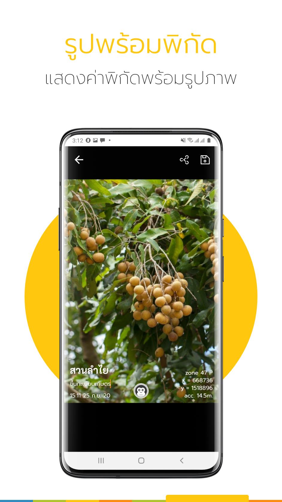
Ling - GIS app, accurate agricultural map data.
GIS map data useful for decision making will come into your hands
Helping to make important decisions about agricultural work will not be missed again.
Ling is a land map data generation app. and calculate the size of the land plot in Thai units
Can send information to relevant people easily. Either via Facebook, LINE or email.
Can upload GIS data to use with the app. Information that is useful to choose will come into your hands make accurate decisions
In addition, to solve the problem of map images not updating or dark, the app supports map images taken by drones.
Drone images are sharp, detailed and updated, helping to serve as a base for precision agriculture.
Because the data is stored in the cloud. Allows app users to access data from any device.
To send suggestions for improvement please send to
[email protected]
Ling 6.6.6 Update
ปรับปรุงประสิทธิภาพโดยรวม
Read More
Related Videos


Previous Versions More
Ling - แอปเพื่อการเกษตรดิจิทัล
6.6.6
XAPK
APKs
October 24, 2024
84.66 MB
Variant
Arch
Version
DPI
Ling - แอปเพื่อการเกษตรดิจิทัล
6.6.5
APK
July 10, 2024
43.78 MB
Requires Android: Android 5.0+
Architecture: arm64-v8a, armeabi-v7a, x86, x86_64
Screen DPI: nodpi
SHA1: 5d361e3bd51fec71fa790b9ef43e430108fbc27c
Size: 43.78 MB
What's New:
ปรับปรุงประสิทธิภาพโดยรวม
Ling - แอปเพื่อการเกษตรดิจิทัล
6.6.5
XAPK
APKs
July 10, 2024
40.8 MB
Requires Android: Android 5.0+
Architecture: arm64-v8a
Screen DPI: nodpi
SHA1: 5059513bedb745fd49abc8d3ebc09c9d0d714b2e
Size: 40.8 MB
What's New:
ปรับปรุงประสิทธิภาพโดยรวม
Ling - แอปเพื่อการเกษตรดิจิทัล
6.6.3
XAPK
APKs
July 8, 2024
40.8 MB
Requires Android: Android 5.0+
Architecture: arm64-v8a
Screen DPI: nodpi
SHA1: 66c5963032b9b1126150fef2cf511622bc17d37c
Size: 40.8 MB
What's New:
ปรับปรุงประสิทธิภาพโดยรวม
More Information
Package Name:
Category:
Update Date:
2024-10-26
Latest Version:
6.6.6
Need Update:
Available on:
Requirements:
Android 5.0+
Report:
Alternatives to Ling
UTM Geo Map
Simple Mapping & GIS Tools.
9.2 1K+
Payke-making shopping
We are carrying out a limited-time campaign to commemorate the launch!
7.3 198
Grab Driver: App for Partners
Earn on the road
8.2 139K+
GLand : GPS Field Area Measure
area measure, land measure, length measure, kml, gps, geojson, measurement app
8.7 5K+
EVA AIR
Stay on top of your travel plans with EVA AIR App.
9.0 677