


AOPA GOの詳細
Aircraft Owners and Pilots Associationからリリースされた『AOPA GO』はツールアプリだ。apkpure.fo/jpから『AOPA GO』のファイルサイズ(APKサイズ):51.17 MB、スクリーンショット、詳細情報などを確認できる。apkpure.fo/jpではAircraft Owners and Pilots Associationより配信したアプリを簡単に検索して見つけることができる。『AOPA GO』に似ているアプリや類似アプリは31個を見つける。現在、AOPA GO appのダウンロードも基本プレイも無料だ。『AOPA GO』のAndroid要件はAndroid 4.4+なので、ご注意ください。APKPure.foあるいはGooglePlayから『AOPA GO apk』の最新バージョンを高速、安全にダウンロードできる。apkpure.fo/jpでは全てのAPK/XAPKファイルがオリジナルなものなので、高速、安全にダウンロードできる。
Available exclusively to AOPA members, AOPA GO delivers essential flight planning tools—AOPA Airports Directory, AOPA Weather and a select set of AOPA Flight Planning features in the palm of your hand.
AOPA GO is a convenient pre-flight planning tool, allowing pilots to search the industry’s most comprehensive airport directory; create, edit and file flight plans; and check a diverse gallery of aviation weather charts. Best of all, AOPA GO syncs all pilot information, aircraft profiles, flight plans, and user waypoints with the AOPA Flight Planner. Large text and different color themes makes the information easy to read in all lighting conditions. Whether you plan your flight at your desk or on the ramp, you’re covered with AOPA.
AOPA Airports Directory
AOPA GO uses your device’s physical location to identify the nearest airports, heliports, and seaplane bases. You can see all the most critical information about each at first glance or drill down to more detailed information with a single tap of the screen. The app also allows you to search for an airport by name, ident, or location and save your favorites for quick access. All the information you need about an airport is readily available—from communications and operations to fuel providers and other services available on the field and nearby.
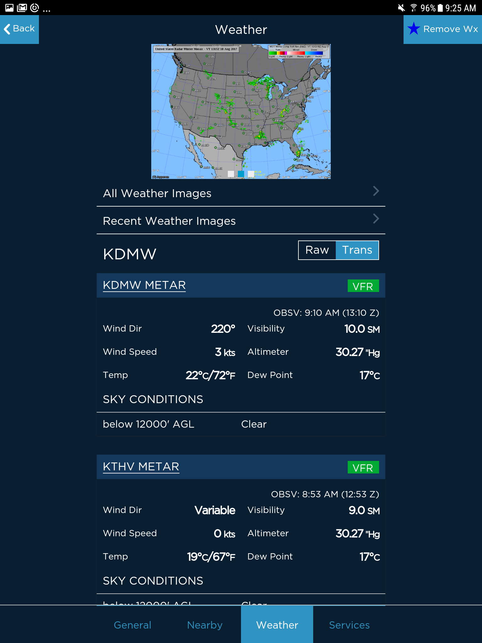
AOPA Weather Charts
AOPA GO Weather is designed to provide “best of breed” aviation weather information by compiling the best sources available into one resource. With information and images from Jeppesen, Aviation Digital Data Service (ADDS), and the National Oceanic and Atmospheric Administration (NOAA), pilots get a complete picture of the weather that could affect their flight. Quickly review the METARs and TAFs closest to your location right on the main Weather screen, or choose from a gallery of national or regional weather chart images. You can also see current and forecast weather conditions along your route of flight using the Route Weather feature. Adverse weather conditions are color-coded based on severity to be more noticeable on METAR and TAF reports.
AOPA Flight Planning, powered by Jeppesen
No matter if you are creating a new flight plan from scratch, or pulling up a saved route to file for flight, AOPA GO has you covered. Built on the same powerful Jeppesen flight planning engine as the AOPA Flight Planner, the app allows you create, edit, and file flight plans and get a weather briefing using CSRA DUATS or Leidos Flight Service. Users of the AOPA Flight Planner can also include any of their saved user-defined waypoints in a flight plan.
AOPA GO is a convenient pre-flight planning tool, allowing pilots to search the industry’s most comprehensive airport directory; create, edit and file flight plans; and check a diverse gallery of aviation weather charts. Best of all, AOPA GO syncs all pilot information, aircraft profiles, flight plans, and user waypoints with the AOPA Flight Planner. Large text and different color themes makes the information easy to read in all lighting conditions. Whether you plan your flight at your desk or on the ramp, you’re covered with AOPA.
AOPA Airports Directory
AOPA GO uses your device’s physical location to identify the nearest airports, heliports, and seaplane bases. You can see all the most critical information about each at first glance or drill down to more detailed information with a single tap of the screen. The app also allows you to search for an airport by name, ident, or location and save your favorites for quick access. All the information you need about an airport is readily available—from communications and operations to fuel providers and other services available on the field and nearby.
AOPA Weather Charts
AOPA GO Weather is designed to provide “best of breed” aviation weather information by compiling the best sources available into one resource. With information and images from Jeppesen, Aviation Digital Data Service (ADDS), and the National Oceanic and Atmospheric Administration (NOAA), pilots get a complete picture of the weather that could affect their flight. Quickly review the METARs and TAFs closest to your location right on the main Weather screen, or choose from a gallery of national or regional weather chart images. You can also see current and forecast weather conditions along your route of flight using the Route Weather feature. Adverse weather conditions are color-coded based on severity to be more noticeable on METAR and TAF reports.
AOPA Flight Planning, powered by Jeppesen
No matter if you are creating a new flight plan from scratch, or pulling up a saved route to file for flight, AOPA GO has you covered. Built on the same powerful Jeppesen flight planning engine as the AOPA Flight Planner, the app allows you create, edit, and file flight plans and get a weather briefing using CSRA DUATS or Leidos Flight Service. Users of the AOPA Flight Planner can also include any of their saved user-defined waypoints in a flight plan.
AOPA GO 1.6.1 アップデート
AOPA GO v 1.6.1 is a minor update with the following changes:
Dew Point – The dew point temperature in METARs is now displayed in both Celsius and Fahrenheit.
Other minor bug fixes and enhancements.
Dew Point – The dew point temperature in METARs is now displayed in both Celsius and Fahrenheit.
Other minor bug fixes and enhancements.
続きを読む
バージョン履歴 もっと見る
AOPA GO
1.6.1
APK
2019年03月31日
51.17 MB
Requires Android: Android 4.4+
Architecture: armeabi, armeabi-v7a, mips, x86
Screen DPI: 120-640dpi
SHA1: f9d89d992db1d7f36dd5971e80e5d20d5475f4cf
Size: 51.17 MB
What's New:
AOPA GO v 1.6.1 is a minor update with the following changes:
Dew Point – The dew point temperature in METARs is now displayed in both Celsius and Fahrenheit.
Other minor bug fixes and enhancements.
Dew Point – The dew point temperature in METARs is now displayed in both Celsius and Fahrenheit.
Other minor bug fixes and enhancements.
AOPA GO
1.6.0
APK
2018年11月20日
51.17 MB
Requires Android: Android 4.4+
Architecture: armeabi, armeabi-v7a, mips, x86
Screen DPI: 120-640dpi
SHA1: 54378721b0f4820e58efd7228bccd9719cc2c562
Size: 51.17 MB
What's New:
Push Notifications: AOPA GO can now send Push Notification Alerts when needed. This is mostly for future use, but notifications may include location oriented TFR alerts, significant weather notices, database update alerts and other pertinent issues.
Airport Satellite Images: The issue with missing airport satellite images has been fixed.
Bug Fixes.
Airport Satellite Images: The issue with missing airport satellite images has been fixed.
Bug Fixes.
AOPA GO
1.5.5
APK
2018年07月21日
50.07 MB
Requires Android: Android 4.4+
Architecture: armeabi, armeabi-v7a, mips, x86
Screen DPI: 120-480dpi
SHA1: 0f1cca44e5ac25d39c38953f31b813e7316e6edc
Size: 50.07 MB
What's New:
AOPA GO version 1.5.5 provides additional data for airport runways and fixes a bug.
Additional Runway Data: Additional data points for runways are now displayed in the app.
Procedure Display Bug: The wrong terminal procedures could be shown in an isolated scenario when viewing procedures at airports that are nearby another airport. This issue has been fixed in this version.
Airport Weather Bug: Fixed an issue with displaying the weather phone number for airports that have them.
AOPA GO
1.5.4
APK
2018年06月21日
50.07 MB
Requires Android: Android 4.4+
Architecture: armeabi, armeabi-v7a, mips, x86
Screen DPI: 120-480dpi
SHA1: 1044cfbc6a1b05634ab11c9ed2031731dfe62e1e
Size: 50.07 MB
What's New:
AOPA GO version 1.5.4 provides additional data for airport runways and fixes a bug when viewing terminal procedures in a specific, isolated scenario.
追加情報
パケージ名:
更新日:
2019-03-25
最新バージョン:
1.6.1
バージョンアップ申請:
Android要件:
Android 4.4+
報告:
AOPA GOの類似アプリ
ZuluLog Pilot Logbook and EFB
パイロット ログ、チャート、ジオリファレンス プレート、ADS-B、重量とバランスなど。
6.6 14
iFly EFB
VFRとIFRの両方のフライトに強力で直感的なEFB。
9.1 32
MyFlightbook for Android
お使いの携帯電話、タブレットから、またはWeb上の飛行日誌にアクセスします。
9.4 27
Avare
航空米国のFAA資料+カナダなどの最新のTPCおよびONCチャート。
9.7 531
RWY by OzRunways
OzRunwaysによるRWYは最も完全な電子フライトバッグを使用するのが最も簡単です。
6.2 104